You are here: Home > Network List > US - United States National Seismic Network Stations List
> Station TZTN Tazewell, Tennessee, USA > Earthquake Result Viewer
TZTN Tazewell, Tennessee, USA - Earthquake Result Viewer
| Earthquake location: |
Near Coast Of Northern Chile |
| Earthquake latitude/longitude: |
-27.2/-71.1 |
| Earthquake time(UTC): |
2006/04/30 (120) 21:40:58 GMT |
| Earthquake Depth: |
12 km |
| Earthquake Magnitude: |
5.9 MB, 6.7 MS, 6.5 MW, 6.3 ML |
| Earthquake Catalog/Contributor: |
WHDF/NEIC |
|
| Network: |
US United States National Seismic Network |
| Station: |
TZTN Tazewell, Tennessee, USA |
| Lat/Lon: |
36.54 N/83.55 W |
| Elevation: |
394 m |
|
| Distance: |
64.5 deg |
| Az: |
348.872 deg |
| Baz: |
167.676 deg |
| Ray Param: |
0.058879513 |
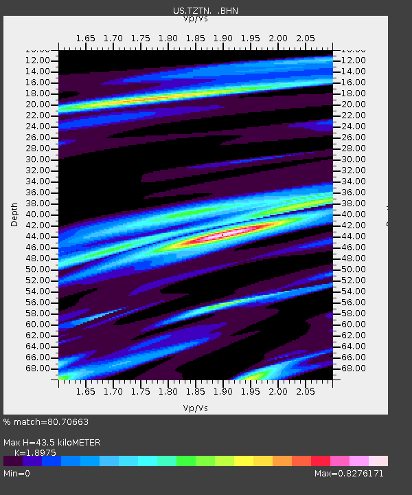
| Estimated Moho Depth: |
43.5 km |
| Estimated Crust Vp/Vs: |
1.90 |
| Assumed Crust Vp: |
6.476 km/s |
| Estimated Crust Vs: |
3.413 km/s |
| Estimated Crust Poisson's Ratio: |
0.31 |
|
| Radial Match: |
80.70663 % |
| Radial Bump: |
400 |
| Transverse Match: |
74.604744 % |
| Transverse Bump: |
400 |
| SOD ConfigId: |
2669 |
| Insert Time: |
2010-03-05 06:31:04.050 +0000 |
| GWidth: |
2.5 |
| Max Bumps: |
400 |
| Tol: |
0.001 |
|
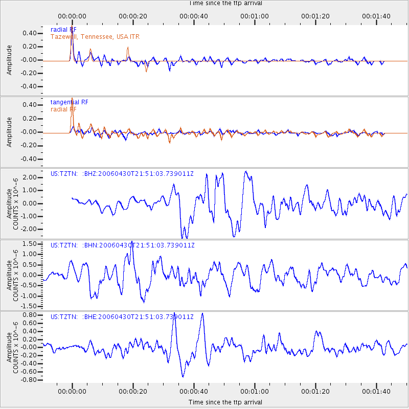
Signal To Noise
| Channel | StoN | STA | LTA |
| US:TZTN: :BHN:20060430T21:51:03.739011Z | 2.3985016 | 4.718158E-7 | 1.9671273E-7 |
| US:TZTN: :BHE:20060430T21:51:03.739011Z | 0.307931 | 4.6406946E-8 | 1.5070566E-7 |
| US:TZTN: :BHZ:20060430T21:51:03.739011Z | 2.189956 | 7.334309E-7 | 3.349067E-7 |
| Arrivals |
| Ps | 6.3 SECOND |
| PpPs | 19 SECOND |
| PsPs/PpSs | 25 SECOND |


