You are here: Home > Network List > US - United States National Seismic Network Stations List
> Station TZTN Tazewell, Tennessee, USA > Earthquake Result Viewer
TZTN Tazewell, Tennessee, USA - Earthquake Result Viewer
| Earthquake location: |
Eastern Siberia, Russia |
| Earthquake latitude/longitude: |
60.5/167.5 |
| Earthquake time(UTC): |
2006/04/29 (119) 16:58:06 GMT |
| Earthquake Depth: |
11 km |
| Earthquake Magnitude: |
6.4 MB, 6.6 MS, 6.6 MW, 6.4 MW |
| Earthquake Catalog/Contributor: |
WHDF/NEIC |
|
| Network: |
US United States National Seismic Network |
| Station: |
TZTN Tazewell, Tennessee, USA |
| Lat/Lon: |
36.54 N/83.55 W |
| Elevation: |
394 m |
|
| Distance: |
67.3 deg |
| Az: |
55.652 deg |
| Baz: |
329.499 deg |
| Ray Param: |
0.057037406 |
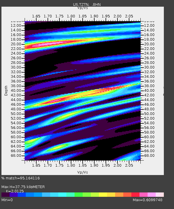
| Estimated Moho Depth: |
37.75 km |
| Estimated Crust Vp/Vs: |
2.01 |
| Assumed Crust Vp: |
6.476 km/s |
| Estimated Crust Vs: |
3.218 km/s |
| Estimated Crust Poisson's Ratio: |
0.34 |
|
| Radial Match: |
95.164116 % |
| Radial Bump: |
400 |
| Transverse Match: |
92.530266 % |
| Transverse Bump: |
399 |
| SOD ConfigId: |
2669 |
| Insert Time: |
2010-03-05 06:31:07.925 +0000 |
| GWidth: |
2.5 |
| Max Bumps: |
400 |
| Tol: |
0.001 |
|

Signal To Noise
| Channel | StoN | STA | LTA |
| US:TZTN: :BHN:20060429T17:08:29.864006Z | 12.986438 | 1.2863904E-6 | 9.905645E-8 |
| US:TZTN: :BHE:20060429T17:08:29.864006Z | 6.878299 | 3.6832068E-7 | 5.3548217E-8 |
| US:TZTN: :BHZ:20060429T17:08:29.864006Z | 23.60294 | 3.5219107E-6 | 1.4921493E-7 |
| Arrivals |
| Ps | 6.1 SECOND |
| PpPs | 17 SECOND |
| PsPs/PpSs | 23 SECOND |


