You are here: Home > Network List > US - United States National Seismic Network Stations List
> Station TZTN Tazewell, Tennessee, USA > Earthquake Result Viewer
TZTN Tazewell, Tennessee, USA - Earthquake Result Viewer
| Earthquake location: |
Eastern Siberia, Russia |
| Earthquake latitude/longitude: |
60.9/167.1 |
| Earthquake time(UTC): |
2006/04/20 (110) 23:25:02 GMT |
| Earthquake Depth: |
22 km |
| Earthquake Magnitude: |
6.8 MB, 7.6 MS, 7.6 MW, 7.3 MW |
| Earthquake Catalog/Contributor: |
WHDF/NEIC |
|
| Network: |
US United States National Seismic Network |
| Station: |
TZTN Tazewell, Tennessee, USA |
| Lat/Lon: |
36.54 N/83.55 W |
| Elevation: |
394 m |
|
| Distance: |
67.2 deg |
| Az: |
55.489 deg |
| Baz: |
330.038 deg |
| Ray Param: |
0.05707061 |
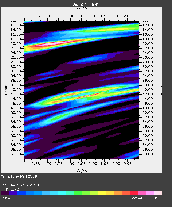
| Estimated Moho Depth: |
19.75 km |
| Estimated Crust Vp/Vs: |
1.72 |
| Assumed Crust Vp: |
6.476 km/s |
| Estimated Crust Vs: |
3.765 km/s |
| Estimated Crust Poisson's Ratio: |
0.24 |
|
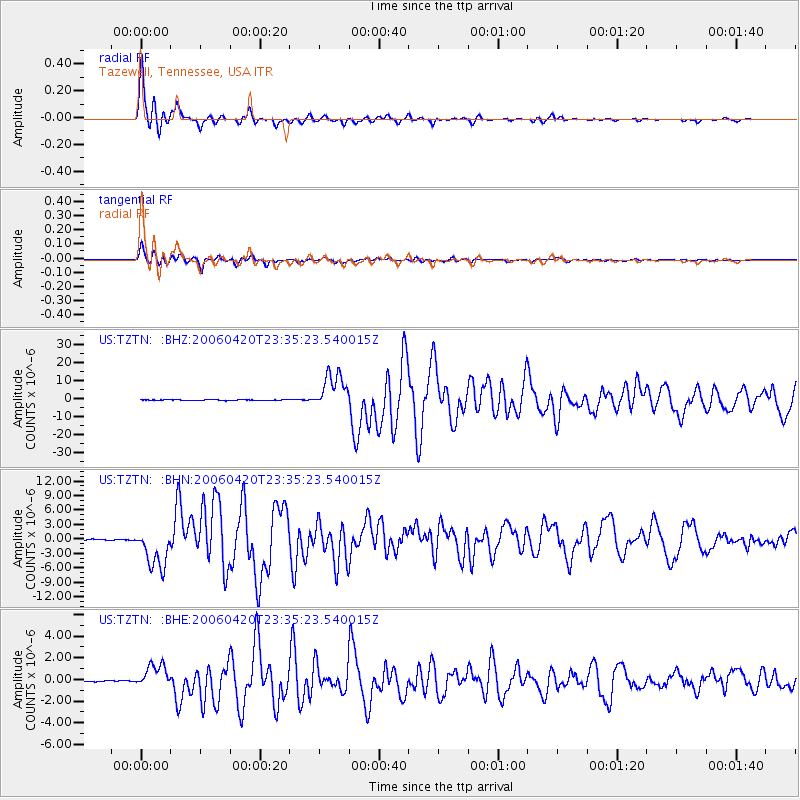
| Radial Match: |
98.10506 % |
| Radial Bump: |
400 |
| Transverse Match: |
96.57552 % |
| Transverse Bump: |
400 |
| SOD ConfigId: |
2669 |
| Insert Time: |
2010-03-05 06:31:09.222 +0000 |
| GWidth: |
2.5 |
| Max Bumps: |
400 |
| Tol: |
0.001 |
|
Signal To Noise
| Channel | StoN | STA | LTA |
| US:TZTN: :BHN:20060420T23:35:23.540015Z | 28.211626 | 4.215431E-6 | 1.4942177E-7 |
| US:TZTN: :BHE:20060420T23:35:23.540015Z | 19.958776 | 1.0978406E-6 | 5.500541E-8 |
| US:TZTN: :BHZ:20060420T23:35:23.540015Z | 57.243523 | 1.0094466E-5 | 1.7634251E-7 |
| Arrivals |
| Ps | 2.3 SECOND |
| PpPs | 8.0 SECOND |
| PsPs/PpSs | 10 SECOND |


