You are here: Home > Network List > TA - USArray Transportable Network (new EarthScope stations) Stations List
> Station D23K Nanushuk River, AK USA > Earthquake Result Viewer
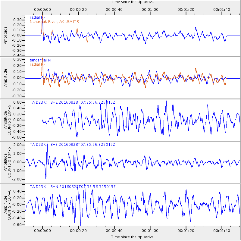
D23K Nanushuk River, AK USA - Earthquake Result Viewer
*The percent match for this event was below the threshold and hence no stack was calculated.
| Earthquake location: |
Irian Jaya, Indonesia |
| Earthquake latitude/longitude: |
-2.8/138.4 |
| Earthquake time(UTC): |
2016/08/28 (241) 07:23:50 GMT |
| Earthquake Depth: |
28 km |
| Earthquake Magnitude: |
5.7 MB |
| Earthquake Catalog/Contributor: |
NEIC PDE/NEIC COMCAT |
|
| Network: |
TA USArray Transportable Network (new EarthScope stations) |
| Station: |
D23K Nanushuk River, AK USA |
| Lat/Lon: |
68.97 N/150.68 W |
| Elevation: |
406 m |
|
| Distance: |
85.8 deg |
| Az: |
20.0 deg |
| Baz: |
251.122 deg |
| Ray Param: |
$rayparam |
*The percent match for this event was below the threshold and hence was not used in the summary stack. |
|
| Radial Match: |
74.23427 % |
| Radial Bump: |
400 |
| Transverse Match: |
74.16115 % |
| Transverse Bump: |
400 |
| SOD ConfigId: |
11737051 |
| Insert Time: |
2019-04-25 09:12:28.986 +0000 |
| GWidth: |
2.5 |
| Max Bumps: |
400 |
| Tol: |
0.001 |
|
Signal To Noise
| Channel | StoN | STA | LTA |
| TA:D23K: :BHZ:20160828T07:35:56.325015Z | 2.5552292 | 8.4084934E-7 | 3.2907005E-7 |
| TA:D23K: :BHN:20160828T07:35:56.325015Z | 0.8221776 | 1.5218623E-7 | 1.8510141E-7 |
| TA:D23K: :BHE:20160828T07:35:56.325015Z | 0.98824495 | 1.9971857E-7 | 2.020942E-7 |
| Arrivals |
| Ps | |
| PpPs | |
| PsPs/PpSs | |


