You are here: Home > Network List > TA - USArray Transportable Network (new EarthScope stations) Stations List
> Station M20K Styx River, AK, USA > Earthquake Result Viewer
M20K Styx River, AK, USA - Earthquake Result Viewer
| Earthquake location: |
Irian Jaya, Indonesia |
| Earthquake latitude/longitude: |
-2.8/138.4 |
| Earthquake time(UTC): |
2016/08/28 (241) 07:23:50 GMT |
| Earthquake Depth: |
28 km |
| Earthquake Magnitude: |
5.7 MB |
| Earthquake Catalog/Contributor: |
NEIC PDE/NEIC COMCAT |
|
| Network: |
TA USArray Transportable Network (new EarthScope stations) |
| Station: |
M20K Styx River, AK, USA |
| Lat/Lon: |
61.88 N/153.13 W |
| Elevation: |
1107 m |
|
| Distance: |
82.5 deg |
| Az: |
26.385 deg |
| Baz: |
249.544 deg |
| Ray Param: |
0.046837006 |
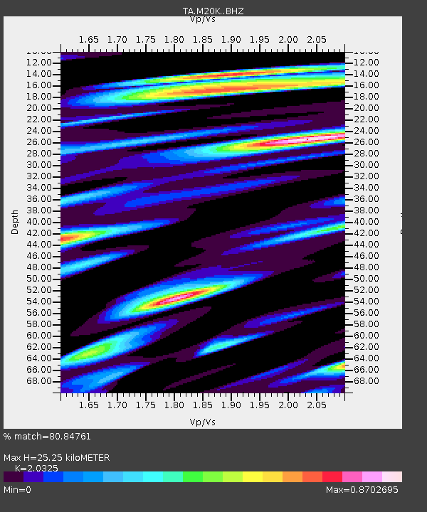
| Estimated Moho Depth: |
25.25 km |
| Estimated Crust Vp/Vs: |
2.03 |
| Assumed Crust Vp: |
6.566 km/s |
| Estimated Crust Vs: |
3.231 km/s |
| Estimated Crust Poisson's Ratio: |
0.34 |
|
| Radial Match: |
80.84761 % |
| Radial Bump: |
374 |
| Transverse Match: |
65.16131 % |
| Transverse Bump: |
400 |
| SOD ConfigId: |
11737051 |
| Insert Time: |
2019-04-25 09:13:08.479 +0000 |
| GWidth: |
2.5 |
| Max Bumps: |
400 |
| Tol: |
0.001 |
|

Signal To Noise
| Channel | StoN | STA | LTA |
| TA:M20K: :BHZ:20160828T07:35:39.275027Z | 8.874279 | 4.4167385E-7 | 4.9770108E-8 |
| TA:M20K: :BHN:20160828T07:35:39.275027Z | 2.7488313 | 1.644328E-7 | 5.9819165E-8 |
| TA:M20K: :BHE:20160828T07:35:39.275027Z | 3.9018645 | 2.1305202E-7 | 5.460262E-8 |
| Arrivals |
| Ps | 4.1 SECOND |
| PpPs | 11 SECOND |
| PsPs/PpSs | 15 SECOND |


