You are here: Home > Network List > 7A - Mid-Atlantic Geophysical Integrative Collaboration Stations List
> Station INTX Elkton, Virginia USA > Earthquake Result Viewer
INTX Elkton, Virginia USA - Earthquake Result Viewer
| Earthquake location: |
North Of Ascension Island |
| Earthquake latitude/longitude: |
-0.0/-17.8 |
| Earthquake time(UTC): |
2016/08/29 (242) 04:29:57 GMT |
| Earthquake Depth: |
10 km |
| Earthquake Magnitude: |
7.1 MWW, 7.1 MWC, 7.4 MI |
| Earthquake Catalog/Contributor: |
NEIC PDE/NEIC COMCAT |
|
| Network: |
7A Mid-Atlantic Geophysical Integrative Collaboration |
| Station: |
INTX Elkton, Virginia USA |
| Lat/Lon: |
38.40 N/78.59 W |
| Elevation: |
320 m |
|
| Distance: |
67.5 deg |
| Az: |
312.078 deg |
| Baz: |
109.142 deg |
| Ray Param: |
0.056941293 |
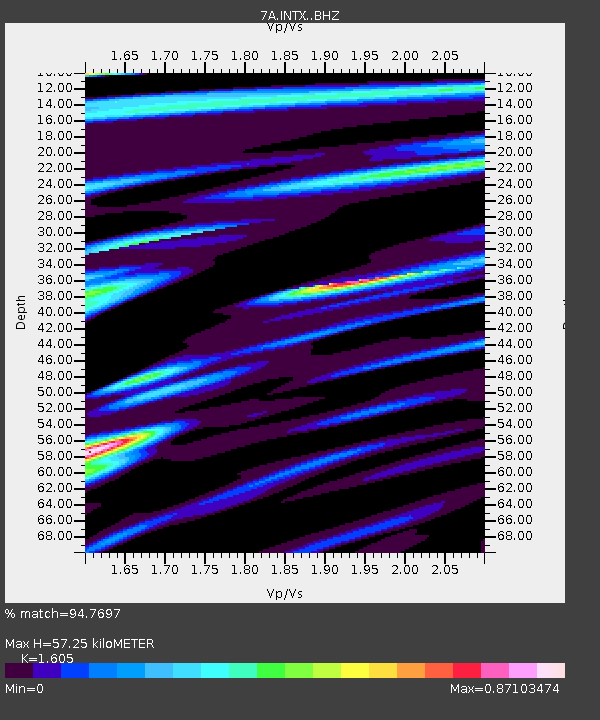
| Estimated Moho Depth: |
57.25 km |
| Estimated Crust Vp/Vs: |
1.61 |
| Assumed Crust Vp: |
6.159 km/s |
| Estimated Crust Vs: |
3.837 km/s |
| Estimated Crust Poisson's Ratio: |
0.18 |
|
| Radial Match: |
94.7697 % |
| Radial Bump: |
385 |
| Transverse Match: |
86.98855 % |
| Transverse Bump: |
400 |
| SOD ConfigId: |
11737051 |
| Insert Time: |
2019-04-25 09:15:12.632 +0000 |
| GWidth: |
2.5 |
| Max Bumps: |
400 |
| Tol: |
0.001 |
|

Signal To Noise
| Channel | StoN | STA | LTA |
| 7A:INTX: :BHZ:20160829T04:40:22.539973Z | 1.4994357 | 1.936856E-7 | 1.2917232E-7 |
| 7A:INTX: :BHN:20160829T04:40:22.539973Z | 2.1796048 | 1.9221811E-7 | 8.818943E-8 |
| 7A:INTX: :BHE:20160829T04:40:22.539973Z | 2.0500722 | 1.456004E-7 | 7.102208E-8 |
| Arrivals |
| Ps | 5.9 SECOND |
| PpPs | 23 SECOND |
| PsPs/PpSs | 29 SECOND |


