You are here: Home > Network List > CN - Canadian National Seismograph Network Stations List
> Station ATKO Atikokan Iron Mine, ON, CA > Earthquake Result Viewer
ATKO Atikokan Iron Mine, ON, CA - Earthquake Result Viewer
| Earthquake location: |
North Of Ascension Island |
| Earthquake latitude/longitude: |
-0.0/-17.8 |
| Earthquake time(UTC): |
2016/08/29 (242) 04:29:57 GMT |
| Earthquake Depth: |
10 km |
| Earthquake Magnitude: |
7.1 MWW, 7.1 MWC, 7.4 MI |
| Earthquake Catalog/Contributor: |
NEIC PDE/NEIC COMCAT |
|
| Network: |
CN Canadian National Seismograph Network |
| Station: |
ATKO Atikokan Iron Mine, ON, CA |
| Lat/Lon: |
48.82 N/91.60 W |
| Elevation: |
383 m |
|
| Distance: |
79.4 deg |
| Az: |
319.79 deg |
| Baz: |
102.353 deg |
| Ray Param: |
0.04899243 |
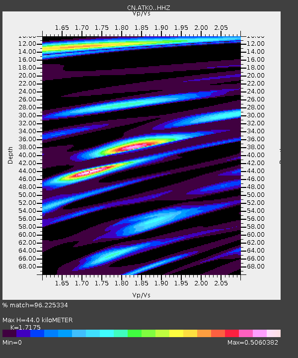
| Estimated Moho Depth: |
44.0 km |
| Estimated Crust Vp/Vs: |
1.72 |
| Assumed Crust Vp: |
6.467 km/s |
| Estimated Crust Vs: |
3.765 km/s |
| Estimated Crust Poisson's Ratio: |
0.24 |
|
| Radial Match: |
96.225334 % |
| Radial Bump: |
219 |
| Transverse Match: |
86.23172 % |
| Transverse Bump: |
400 |
| SOD ConfigId: |
11737051 |
| Insert Time: |
2019-04-25 09:16:38.403 +0000 |
| GWidth: |
2.5 |
| Max Bumps: |
400 |
| Tol: |
0.001 |
|

Signal To Noise
| Channel | StoN | STA | LTA |
| CN:ATKO: :HHZ:20160829T04:41:32.60998Z | 2.3826401 | 1.7892214E-7 | 7.509407E-8 |
| CN:ATKO: :HHN:20160829T04:41:32.60998Z | 0.88973504 | 5.2613682E-8 | 5.91341E-8 |
| CN:ATKO: :HHE:20160829T04:41:32.60998Z | 1.5219916 | 6.9173595E-8 | 4.5449394E-8 |
| Arrivals |
| Ps | 5.0 SECOND |
| PpPs | 18 SECOND |
| PsPs/PpSs | 23 SECOND |


