You are here: Home > Network List > CN - Canadian National Seismograph Network Stations List
> Station SADO Sadowa, ON, CA > Earthquake Result Viewer
SADO Sadowa, ON, CA - Earthquake Result Viewer

| Earthquake location: |
North Of Ascension Island |
| Earthquake latitude/longitude: |
-0.0/-17.8 |
| Earthquake time(UTC): |
2016/08/29 (242) 04:29:57 GMT |
| Earthquake Depth: |
10 km |
| Earthquake Magnitude: |
7.1 MWW, 7.1 MWC, 7.4 MI |
| Earthquake Catalog/Contributor: |
NEIC PDE/NEIC COMCAT |
|
| Network: |
CN Canadian National Seismograph Network |
| Station: |
SADO Sadowa, ON, CA |
| Lat/Lon: |
44.77 N/79.14 W |
| Elevation: |
228 m |
|
| Distance: |
70.0 deg |
| Az: |
318.333 deg |
| Baz: |
111.044 deg |
| Ray Param: |
0.05524698 |
| Estimated Moho Depth: |
37.25 km |
| Estimated Crust Vp/Vs: |
1.75 |
| Assumed Crust Vp: |
6.577 km/s |
| Estimated Crust Vs: |
3.748 km/s |
| Estimated Crust Poisson's Ratio: |
0.26 |
|
| Radial Match: |
94.7865 % |
| Radial Bump: |
311 |
| Transverse Match: |
91.841415 % |
| Transverse Bump: |
389 |
| SOD ConfigId: |
11737051 |
| Insert Time: |
2019-04-25 09:16:49.717 +0000 |
| GWidth: |
2.5 |
| Max Bumps: |
400 |
| Tol: |
0.001 |
|
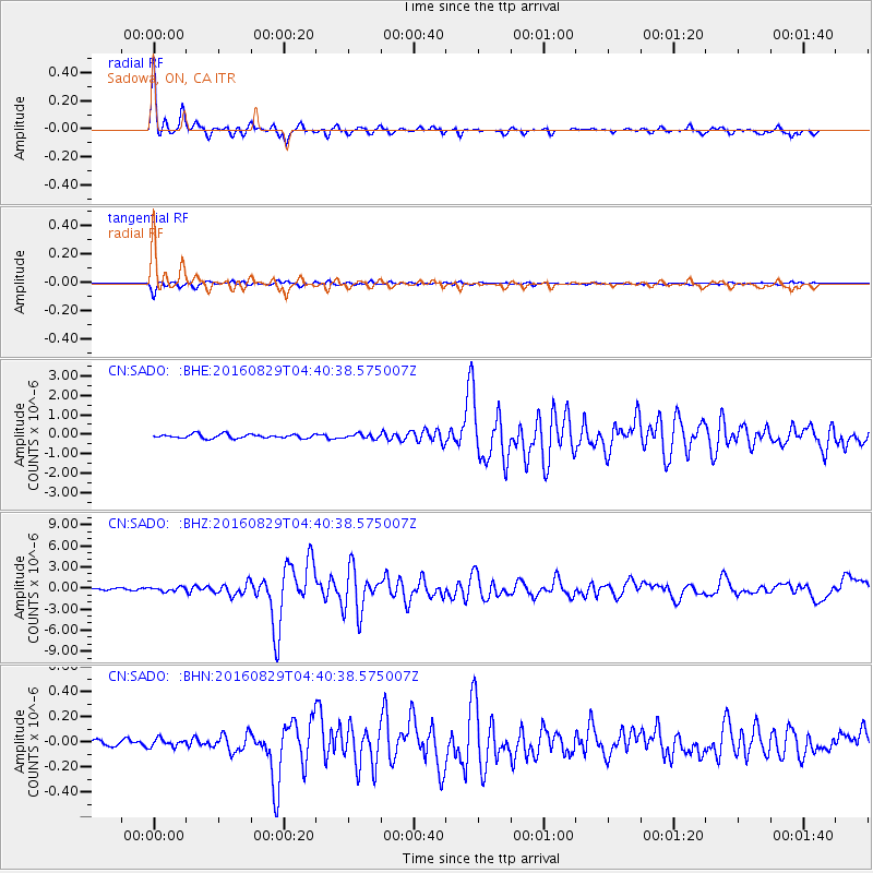
Signal To Noise
| Channel | StoN | STA | LTA |
| CN:SADO: :BHZ:20160829T04:40:38.575007Z | 1.8192077 | 2.818299E-7 | 1.5491904E-7 |
| CN:SADO: :BHN:20160829T04:40:38.575007Z | 1.3583685 | 3.219168E-8 | 2.3698782E-8 |
| CN:SADO: :BHE:20160829T04:40:38.575007Z | 1.1046348 | 1.1424935E-7 | 1.0342726E-7 |
| Arrivals |
| Ps | 4.4 SECOND |
| PpPs | 15 SECOND |
| PsPs/PpSs | 19 SECOND |


