You are here: Home > Network List > LD - Lamont-Doherty Cooperative Seismographic Network Stations List
> Station BRNJ Basking Ridge, New Jersey > Earthquake Result Viewer
BRNJ Basking Ridge, New Jersey - Earthquake Result Viewer
| Earthquake location: |
North Of Ascension Island |
| Earthquake latitude/longitude: |
-0.0/-17.8 |
| Earthquake time(UTC): |
2016/08/29 (242) 04:29:57 GMT |
| Earthquake Depth: |
10 km |
| Earthquake Magnitude: |
7.1 MWW, 7.1 MWC, 7.4 MI |
| Earthquake Catalog/Contributor: |
NEIC PDE/NEIC COMCAT |
|
| Network: |
LD Lamont-Doherty Cooperative Seismographic Network |
| Station: |
BRNJ Basking Ridge, New Jersey |
| Lat/Lon: |
40.68 N/74.57 W |
| Elevation: |
50 m |
|
| Distance: |
65.4 deg |
| Az: |
315.615 deg |
| Baz: |
113.108 deg |
| Ray Param: |
0.058309607 |
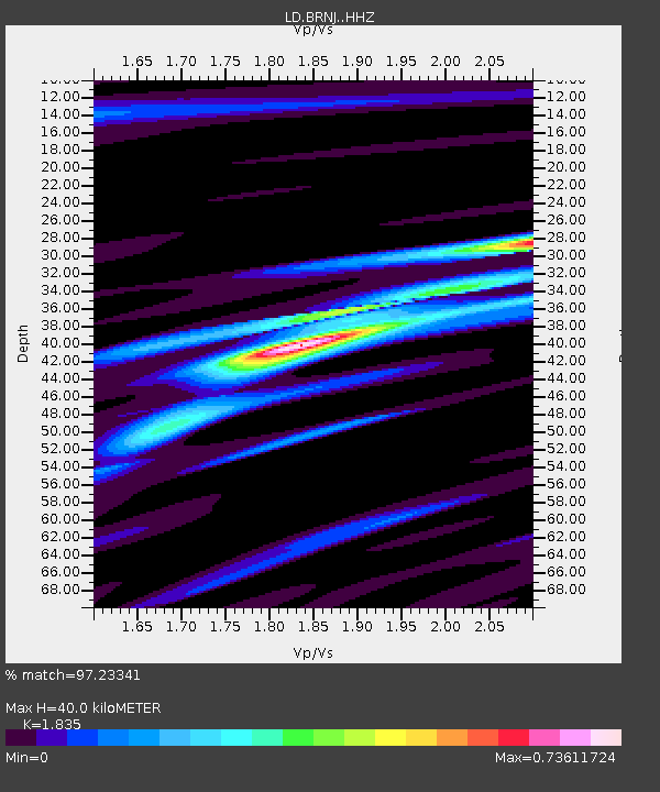
| Estimated Moho Depth: |
40.0 km |
| Estimated Crust Vp/Vs: |
1.84 |
| Assumed Crust Vp: |
6.283 km/s |
| Estimated Crust Vs: |
3.424 km/s |
| Estimated Crust Poisson's Ratio: |
0.29 |
|
| Radial Match: |
97.23341 % |
| Radial Bump: |
225 |
| Transverse Match: |
93.64392 % |
| Transverse Bump: |
400 |
| SOD ConfigId: |
11737051 |
| Insert Time: |
2019-04-25 09:18:20.459 +0000 |
| GWidth: |
2.5 |
| Max Bumps: |
400 |
| Tol: |
0.001 |
|
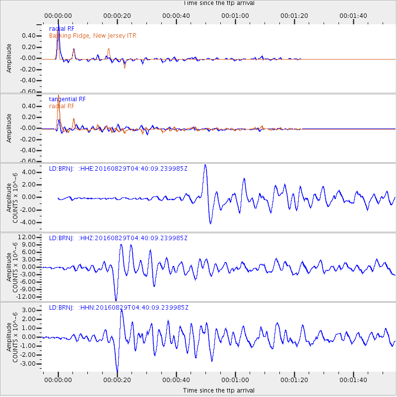
Signal To Noise
| Channel | StoN | STA | LTA |
| LD:BRNJ: :HHZ:20160829T04:40:09.239985Z | 2.5673397 | 3.405725E-7 | 1.326558E-7 |
| LD:BRNJ: :HHN:20160829T04:40:09.239985Z | 1.1794231 | 9.190677E-8 | 7.7925186E-8 |
| LD:BRNJ: :HHE:20160829T04:40:09.239985Z | 1.7713609 | 1.8209415E-7 | 1.0279902E-7 |
| Arrivals |
| Ps | 5.5 SECOND |
| PpPs | 17 SECOND |
| PsPs/PpSs | 23 SECOND |


