You are here: Home > Network List > US - United States National Seismic Network Stations List
> Station RSSD Black Hills, South Dakota, USA > Earthquake Result Viewer
RSSD Black Hills, South Dakota, USA - Earthquake Result Viewer
| Earthquake location: |
Easter Island Region |
| Earthquake latitude/longitude: |
-26.5/-113.8 |
| Earthquake time(UTC): |
2004/11/28 (333) 02:35:13 GMT |
| Earthquake Depth: |
10 km |
| Earthquake Magnitude: |
5.6 MB, 6.1 MS, 6.6 MW, 6.5 MW |
| Earthquake Catalog/Contributor: |
WHDF/NEIC |
|
| Network: |
US United States National Seismic Network |
| Station: |
RSSD Black Hills, South Dakota, USA |
| Lat/Lon: |
44.12 N/104.04 W |
| Elevation: |
2060 m |
|
| Distance: |
70.9 deg |
| Az: |
7.454 deg |
| Baz: |
189.287 deg |
| Ray Param: |
0.054695617 |
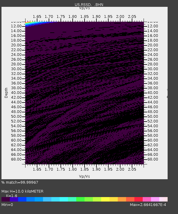
| Estimated Moho Depth: |
10.0 km |
| Estimated Crust Vp/Vs: |
1.60 |
| Assumed Crust Vp: |
6.242 km/s |
| Estimated Crust Vs: |
3.901 km/s |
| Estimated Crust Poisson's Ratio: |
0.18 |
|
| Radial Match: |
99.99967 % |
| Radial Bump: |
2 |
| Transverse Match: |
99.999794 % |
| Transverse Bump: |
2 |
| SOD ConfigId: |
110165 |
| Insert Time: |
2010-03-05 06:31:48.701 +0000 |
| GWidth: |
2.5 |
| Max Bumps: |
400 |
| Tol: |
0.001 |
|

Signal To Noise
| Channel | StoN | STA | LTA |
| US:RSSD: :BHN:20041128T02:45:59.160Z | 0.93190575 | 9.895018E-9 | 1.0618046E-8 |
| US:RSSD: :BHE:20041128T02:45:59.160Z | 0.86141086 | 3.6297358E-9 | 4.2137107E-9 |
| US:RSSD: :BHZ:20041128T02:45:59.160Z | 0.9123282 | 2.3311873E-8 | 2.5552069E-8 |
| Arrivals |
| Ps | 1.0 SECOND |
| PpPs | 4.0 SECOND |
| PsPs/PpSs | 5.0 SECOND |


