You are here: Home > Network List > N4 - Central and EAstern US Network Stations List
> Station E43A Lone Tree Farm, Eben Junction, MI, USA > Earthquake Result Viewer
E43A Lone Tree Farm, Eben Junction, MI, USA - Earthquake Result Viewer
| Earthquake location: |
North Of Ascension Island |
| Earthquake latitude/longitude: |
-0.0/-17.8 |
| Earthquake time(UTC): |
2016/08/29 (242) 04:29:57 GMT |
| Earthquake Depth: |
10 km |
| Earthquake Magnitude: |
7.1 MWW, 7.1 MWC, 7.4 MI |
| Earthquake Catalog/Contributor: |
NEIC PDE/NEIC COMCAT |
|
| Network: |
N4 Central and EAstern US Network |
| Station: |
E43A Lone Tree Farm, Eben Junction, MI, USA |
| Lat/Lon: |
46.38 N/87.00 W |
| Elevation: |
303 m |
|
| Distance: |
75.8 deg |
| Az: |
318.123 deg |
| Baz: |
105.386 deg |
| Ray Param: |
0.051438283 |
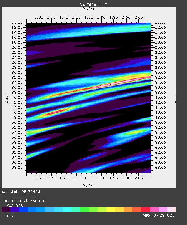
| Estimated Moho Depth: |
34.5 km |
| Estimated Crust Vp/Vs: |
1.93 |
| Assumed Crust Vp: |
6.472 km/s |
| Estimated Crust Vs: |
3.345 km/s |
| Estimated Crust Poisson's Ratio: |
0.32 |
|
| Radial Match: |
95.78426 % |
| Radial Bump: |
292 |
| Transverse Match: |
89.40675 % |
| Transverse Bump: |
326 |
| SOD ConfigId: |
11737051 |
| Insert Time: |
2019-04-25 09:19:03.779 +0000 |
| GWidth: |
2.5 |
| Max Bumps: |
400 |
| Tol: |
0.001 |
|

Signal To Noise
| Channel | StoN | STA | LTA |
| N4:E43A: :HHZ:20160829T04:41:12.499995Z | 2.2108755 | 1.4896229E-7 | 6.737706E-8 |
| N4:E43A: :HHN:20160829T04:41:12.499995Z | 0.5556577 | 5.5393674E-8 | 9.969029E-8 |
| N4:E43A: :HHE:20160829T04:41:12.499995Z | 1.819849 | 1.3644308E-7 | 7.497494E-8 |
| Arrivals |
| Ps | 5.1 SECOND |
| PpPs | 15 SECOND |
| PsPs/PpSs | 20 SECOND |


