You are here: Home > Network List > N4 - Central and EAstern US Network Stations List
> Station J47A Sunmer, MI, USA > Earthquake Result Viewer
J47A Sunmer, MI, USA - Earthquake Result Viewer
| Earthquake location: |
North Of Ascension Island |
| Earthquake latitude/longitude: |
-0.0/-17.8 |
| Earthquake time(UTC): |
2016/08/29 (242) 04:29:57 GMT |
| Earthquake Depth: |
10 km |
| Earthquake Magnitude: |
7.1 MWW, 7.1 MWC, 7.4 MI |
| Earthquake Catalog/Contributor: |
NEIC PDE/NEIC COMCAT |
|
| Network: |
N4 Central and EAstern US Network |
| Station: |
J47A Sunmer, MI, USA |
| Lat/Lon: |
43.24 N/84.82 W |
| Elevation: |
236 m |
|
| Distance: |
73.4 deg |
| Az: |
315.429 deg |
| Baz: |
106.199 deg |
| Ray Param: |
0.05300524 |
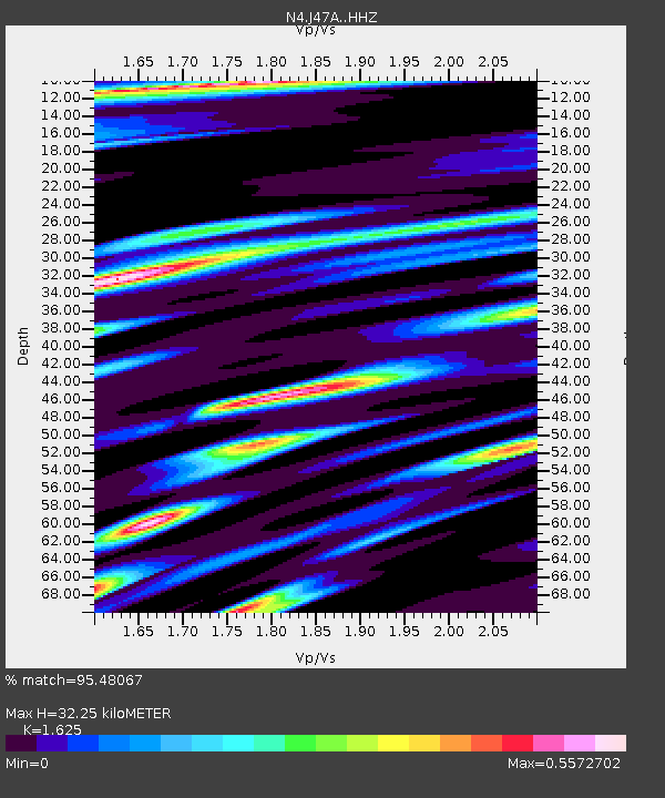
| Estimated Moho Depth: |
32.25 km |
| Estimated Crust Vp/Vs: |
1.62 |
| Assumed Crust Vp: |
6.483 km/s |
| Estimated Crust Vs: |
3.989 km/s |
| Estimated Crust Poisson's Ratio: |
0.20 |
|
| Radial Match: |
95.48067 % |
| Radial Bump: |
369 |
| Transverse Match: |
86.84252 % |
| Transverse Bump: |
400 |
| SOD ConfigId: |
11737051 |
| Insert Time: |
2019-04-25 09:19:16.089 +0000 |
| GWidth: |
2.5 |
| Max Bumps: |
400 |
| Tol: |
0.001 |
|

Signal To Noise
| Channel | StoN | STA | LTA |
| N4:J47A: :HHZ:20160829T04:40:58.929988Z | 3.2723358 | 3.8342748E-7 | 1.1717242E-7 |
| N4:J47A: :HHN:20160829T04:40:58.929988Z | 1.783122 | 2.4658164E-7 | 1.3828647E-7 |
| N4:J47A: :HHE:20160829T04:40:58.929988Z | 2.0821548 | 2.4849572E-7 | 1.1934546E-7 |
| Arrivals |
| Ps | 3.2 SECOND |
| PpPs | 13 SECOND |
| PsPs/PpSs | 16 SECOND |


