You are here: Home > Network List > N4 - Central and EAstern US Network Stations List
> Station P43A Skaggs, Pawnee, IL, USA > Earthquake Result Viewer
P43A Skaggs, Pawnee, IL, USA - Earthquake Result Viewer
| Earthquake location: |
North Of Ascension Island |
| Earthquake latitude/longitude: |
-0.0/-17.8 |
| Earthquake time(UTC): |
2016/08/29 (242) 04:29:57 GMT |
| Earthquake Depth: |
10 km |
| Earthquake Magnitude: |
7.1 MWW, 7.1 MWC, 7.4 MI |
| Earthquake Catalog/Contributor: |
NEIC PDE/NEIC COMCAT |
|
| Network: |
N4 Central and EAstern US Network |
| Station: |
P43A Skaggs, Pawnee, IL, USA |
| Lat/Lon: |
39.64 N/89.52 W |
| Elevation: |
176 m |
|
| Distance: |
76.0 deg |
| Az: |
310.928 deg |
| Baz: |
101.91 deg |
| Ray Param: |
0.051293854 |
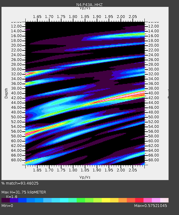
| Estimated Moho Depth: |
31.75 km |
| Estimated Crust Vp/Vs: |
1.60 |
| Assumed Crust Vp: |
6.444 km/s |
| Estimated Crust Vs: |
4.027 km/s |
| Estimated Crust Poisson's Ratio: |
0.18 |
|
| Radial Match: |
93.46025 % |
| Radial Bump: |
294 |
| Transverse Match: |
85.081406 % |
| Transverse Bump: |
400 |
| SOD ConfigId: |
11737051 |
| Insert Time: |
2019-04-25 09:19:44.689 +0000 |
| GWidth: |
2.5 |
| Max Bumps: |
400 |
| Tol: |
0.001 |
|

Signal To Noise
| Channel | StoN | STA | LTA |
| N4:P43A: :HHZ:20160829T04:41:13.710017Z | 4.0676384 | 3.2472911E-7 | 7.983235E-8 |
| N4:P43A: :HHN:20160829T04:41:13.710017Z | 0.4847459 | 5.1424372E-8 | 1.0608522E-7 |
| N4:P43A: :HHE:20160829T04:41:13.710017Z | 1.8184222 | 1.5160504E-7 | 8.3371745E-8 |
| Arrivals |
| Ps | 3.1 SECOND |
| PpPs | 12 SECOND |
| PsPs/PpSs | 15 SECOND |


