You are here: Home > Network List > N4 - Central and EAstern US Network Stations List
> Station Q51A Peebles, OH, USA > Earthquake Result Viewer
Q51A Peebles, OH, USA - Earthquake Result Viewer
| Earthquake location: |
North Of Ascension Island |
| Earthquake latitude/longitude: |
-0.0/-17.8 |
| Earthquake time(UTC): |
2016/08/29 (242) 04:29:57 GMT |
| Earthquake Depth: |
10 km |
| Earthquake Magnitude: |
7.1 MWW, 7.1 MWC, 7.4 MI |
| Earthquake Catalog/Contributor: |
NEIC PDE/NEIC COMCAT |
|
| Network: |
N4 Central and EAstern US Network |
| Station: |
Q51A Peebles, OH, USA |
| Lat/Lon: |
39.03 N/83.35 W |
| Elevation: |
362 m |
|
| Distance: |
71.2 deg |
| Az: |
311.51 deg |
| Baz: |
105.975 deg |
| Ray Param: |
0.05448287 |
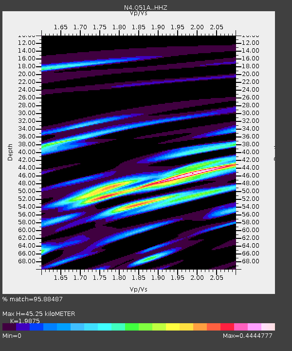
| Estimated Moho Depth: |
45.25 km |
| Estimated Crust Vp/Vs: |
1.99 |
| Assumed Crust Vp: |
6.232 km/s |
| Estimated Crust Vs: |
3.135 km/s |
| Estimated Crust Poisson's Ratio: |
0.33 |
|
| Radial Match: |
95.88487 % |
| Radial Bump: |
293 |
| Transverse Match: |
86.98238 % |
| Transverse Bump: |
400 |
| SOD ConfigId: |
11737051 |
| Insert Time: |
2019-04-25 09:19:48.975 +0000 |
| GWidth: |
2.5 |
| Max Bumps: |
400 |
| Tol: |
0.001 |
|

Signal To Noise
| Channel | StoN | STA | LTA |
| N4:Q51A: :HHZ:20160829T04:40:45.599971Z | 2.5670242 | 1.7350581E-7 | 6.759025E-8 |
| N4:Q51A: :HHN:20160829T04:40:45.599971Z | 1.5341014 | 9.296654E-8 | 6.0599994E-8 |
| N4:Q51A: :HHE:20160829T04:40:45.599971Z | 1.3441869 | 1.7768551E-7 | 1.3218809E-7 |
| Arrivals |
| Ps | 7.4 SECOND |
| PpPs | 21 SECOND |
| PsPs/PpSs | 28 SECOND |


