You are here: Home > Network List > N4 - Central and EAstern US Network Stations List
> Station W45B Hickory Valley, TN, USA > Earthquake Result Viewer
W45B Hickory Valley, TN, USA - Earthquake Result Viewer
| Earthquake location: |
North Of Ascension Island |
| Earthquake latitude/longitude: |
-0.0/-17.8 |
| Earthquake time(UTC): |
2016/08/29 (242) 04:29:57 GMT |
| Earthquake Depth: |
10 km |
| Earthquake Magnitude: |
7.1 MWW, 7.1 MWC, 7.4 MI |
| Earthquake Catalog/Contributor: |
NEIC PDE/NEIC COMCAT |
|
| Network: |
N4 Central and EAstern US Network |
| Station: |
W45B Hickory Valley, TN, USA |
| Lat/Lon: |
35.16 N/89.19 W |
| Elevation: |
182 m |
|
| Distance: |
74.8 deg |
| Az: |
306.449 deg |
| Baz: |
100.985 deg |
| Ray Param: |
0.052061554 |
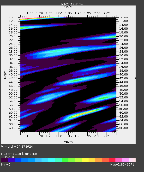
| Estimated Moho Depth: |
10.25 km |
| Estimated Crust Vp/Vs: |
1.60 |
| Assumed Crust Vp: |
6.38 km/s |
| Estimated Crust Vs: |
3.988 km/s |
| Estimated Crust Poisson's Ratio: |
0.18 |
|
| Radial Match: |
94.873924 % |
| Radial Bump: |
335 |
| Transverse Match: |
90.461655 % |
| Transverse Bump: |
395 |
| SOD ConfigId: |
11737051 |
| Insert Time: |
2019-04-25 09:20:13.294 +0000 |
| GWidth: |
2.5 |
| Max Bumps: |
400 |
| Tol: |
0.001 |
|

Signal To Noise
| Channel | StoN | STA | LTA |
| N4:W45B: :HHZ:20160829T04:41:07.11999Z | 10.404509 | 6.8457E-7 | 6.579551E-8 |
| N4:W45B: :HHN:20160829T04:41:07.11999Z | 1.0380155 | 2.779389E-7 | 2.6775987E-7 |
| N4:W45B: :HHE:20160829T04:41:07.11999Z | 1.5441809 | 2.502137E-7 | 1.6203653E-7 |
| Arrivals |
| Ps | 1.0 SECOND |
| PpPs | 4.0 SECOND |
| PsPs/PpSs | 5.0 SECOND |


