You are here: Home > Network List > N4 - Central and EAstern US Network Stations List
> Station Y45B Coffeeville, MS, USA > Earthquake Result Viewer
Y45B Coffeeville, MS, USA - Earthquake Result Viewer
| Earthquake location: |
North Of Ascension Island |
| Earthquake latitude/longitude: |
-0.0/-17.8 |
| Earthquake time(UTC): |
2016/08/29 (242) 04:29:57 GMT |
| Earthquake Depth: |
10 km |
| Earthquake Magnitude: |
7.1 MWW, 7.1 MWC, 7.4 MI |
| Earthquake Catalog/Contributor: |
NEIC PDE/NEIC COMCAT |
|
| Network: |
N4 Central and EAstern US Network |
| Station: |
Y45B Coffeeville, MS, USA |
| Lat/Lon: |
33.87 N/89.54 W |
| Elevation: |
101 m |
|
| Distance: |
74.9 deg |
| Az: |
305.082 deg |
| Baz: |
100.426 deg |
| Ray Param: |
0.05202761 |
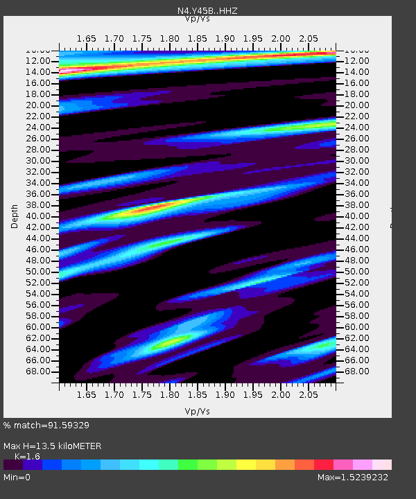
| Estimated Moho Depth: |
13.5 km |
| Estimated Crust Vp/Vs: |
1.60 |
| Assumed Crust Vp: |
6.201 km/s |
| Estimated Crust Vs: |
3.876 km/s |
| Estimated Crust Poisson's Ratio: |
0.18 |
|
| Radial Match: |
91.59329 % |
| Radial Bump: |
339 |
| Transverse Match: |
89.708336 % |
| Transverse Bump: |
400 |
| SOD ConfigId: |
11737051 |
| Insert Time: |
2019-04-25 09:20:17.030 +0000 |
| GWidth: |
2.5 |
| Max Bumps: |
400 |
| Tol: |
0.001 |
|

Signal To Noise
| Channel | StoN | STA | LTA |
| N4:Y45B: :HHZ:20160829T04:41:07.410029Z | 2.5599592 | 3.0384876E-7 | 1.1869282E-7 |
| N4:Y45B: :HHN:20160829T04:41:07.410029Z | 0.7987885 | 1.9641337E-7 | 2.4588908E-7 |
| N4:Y45B: :HHE:20160829T04:41:07.410029Z | 0.659948 | 1.4419129E-7 | 2.1848888E-7 |
| Arrivals |
| Ps | 1.4 SECOND |
| PpPs | 5.5 SECOND |
| PsPs/PpSs | 6.8 SECOND |


