You are here: Home > Network List > OX - North-East Italy Seismic Network Stations List
> Station FUSE Fusea > Earthquake Result Viewer
FUSE Fusea - Earthquake Result Viewer
| Earthquake location: |
North Of Ascension Island |
| Earthquake latitude/longitude: |
-0.0/-17.8 |
| Earthquake time(UTC): |
2016/08/29 (242) 04:29:57 GMT |
| Earthquake Depth: |
10 km |
| Earthquake Magnitude: |
7.1 MWW, 7.1 MWC, 7.4 MI |
| Earthquake Catalog/Contributor: |
NEIC PDE/NEIC COMCAT |
|
| Network: |
OX North-East Italy Seismic Network |
| Station: |
FUSE Fusea |
| Lat/Lon: |
46.41 N/13.00 E |
| Elevation: |
520 m |
|
| Distance: |
53.6 deg |
| Az: |
26.14 deg |
| Baz: |
219.552 deg |
| Ray Param: |
0.06599559 |
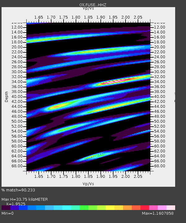
| Estimated Moho Depth: |
33.75 km |
| Estimated Crust Vp/Vs: |
1.95 |
| Assumed Crust Vp: |
6.35 km/s |
| Estimated Crust Vs: |
3.252 km/s |
| Estimated Crust Poisson's Ratio: |
0.32 |
|
| Radial Match: |
90.233 % |
| Radial Bump: |
400 |
| Transverse Match: |
85.62937 % |
| Transverse Bump: |
400 |
| SOD ConfigId: |
11737051 |
| Insert Time: |
2019-04-25 09:21:20.972 +0000 |
| GWidth: |
2.5 |
| Max Bumps: |
400 |
| Tol: |
0.001 |
|

Signal To Noise
| Channel | StoN | STA | LTA |
| OX:FUSE: :HHZ:20160829T04:38:48.03802Z | 7.5215364 | 6.1562116E-7 | 8.1847794E-8 |
| OX:FUSE: :HHN:20160829T04:38:48.03802Z | 2.8634882 | 2.7984862E-7 | 9.7729966E-8 |
| OX:FUSE: :HHE:20160829T04:38:48.03802Z | 2.691404 | 1.7977301E-7 | 6.679525E-8 |
| Arrivals |
| Ps | 5.3 SECOND |
| PpPs | 15 SECOND |
| PsPs/PpSs | 20 SECOND |


