You are here: Home > Network List > PR - Puerto Rico Seismic Network (PRSN) & Puerto Rico Strong Motion Program (PRSMP) Stations List
> Station MLPR Magueyes > Earthquake Result Viewer
MLPR Magueyes - Earthquake Result Viewer
| Earthquake location: |
North Of Ascension Island |
| Earthquake latitude/longitude: |
-0.0/-17.8 |
| Earthquake time(UTC): |
2016/08/29 (242) 04:29:57 GMT |
| Earthquake Depth: |
10 km |
| Earthquake Magnitude: |
7.1 MWW, 7.1 MWC, 7.4 MI |
| Earthquake Catalog/Contributor: |
NEIC PDE/NEIC COMCAT |
|
| Network: |
PR Puerto Rico Seismic Network (PRSN) & Puerto Rico Strong Motion Program (PRSMP) |
| Station: |
MLPR Magueyes |
| Lat/Lon: |
17.97 N/67.04 W |
| Elevation: |
0.0 m |
|
| Distance: |
51.6 deg |
| Az: |
293.083 deg |
| Baz: |
104.873 deg |
| Ray Param: |
0.06732628 |
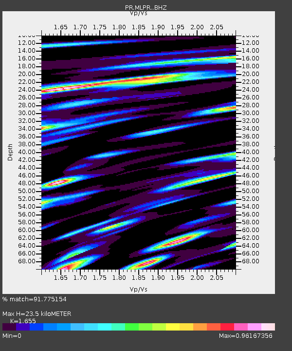
| Estimated Moho Depth: |
23.5 km |
| Estimated Crust Vp/Vs: |
1.65 |
| Assumed Crust Vp: |
4.082 km/s |
| Estimated Crust Vs: |
2.467 km/s |
| Estimated Crust Poisson's Ratio: |
0.21 |
|
| Radial Match: |
91.775154 % |
| Radial Bump: |
400 |
| Transverse Match: |
84.41396 % |
| Transverse Bump: |
400 |
| SOD ConfigId: |
11737051 |
| Insert Time: |
2019-04-25 09:21:56.114 +0000 |
| GWidth: |
2.5 |
| Max Bumps: |
400 |
| Tol: |
0.001 |
|

Signal To Noise
| Channel | StoN | STA | LTA |
| PR:MLPR: :BHZ:20160829T04:38:33.114985Z | 9.998684 | 9.303256E-7 | 9.3044804E-8 |
| PR:MLPR: :BHN:20160829T04:38:33.114985Z | 1.3656759 | 1.3186683E-7 | 9.655792E-8 |
| PR:MLPR: :BHE:20160829T04:38:33.114985Z | 4.4831347 | 3.8881706E-7 | 8.672884E-8 |
| Arrivals |
| Ps | 3.9 SECOND |
| PpPs | 15 SECOND |
| PsPs/PpSs | 19 SECOND |


