You are here: Home > Network List > TA - USArray Transportable Network (new EarthScope stations) Stations List
> Station 833A Chaparral WMA, Artesia Wells, TX, USA > Earthquake Result Viewer
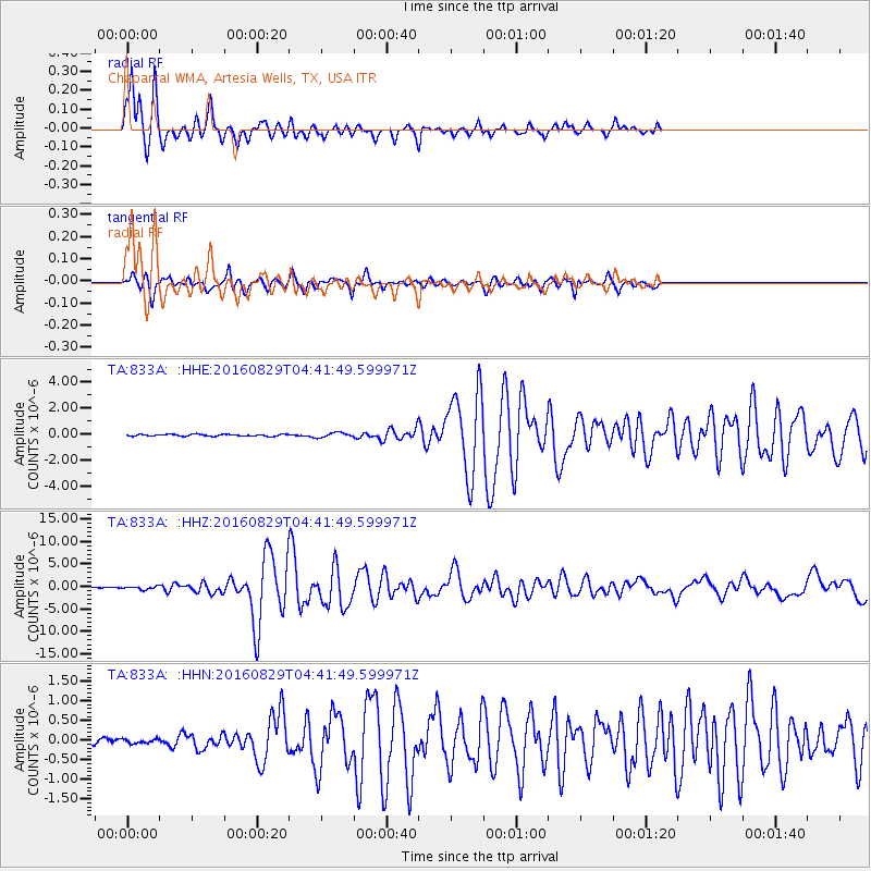
833A Chaparral WMA, Artesia Wells, TX, USA - Earthquake Result Viewer

| Earthquake location: |
North Of Ascension Island |
| Earthquake latitude/longitude: |
-0.0/-17.8 |
| Earthquake time(UTC): |
2016/08/29 (242) 04:29:57 GMT |
| Earthquake Depth: |
10 km |
| Earthquake Magnitude: |
7.1 MWW, 7.1 MWC, 7.4 MI |
| Earthquake Catalog/Contributor: |
NEIC PDE/NEIC COMCAT |
|
| Network: |
TA USArray Transportable Network (new EarthScope stations) |
| Station: |
833A Chaparral WMA, Artesia Wells, TX, USA |
| Lat/Lon: |
28.32 N/99.39 W |
| Elevation: |
171 m |
|
| Distance: |
82.6 deg |
| Az: |
298.429 deg |
| Baz: |
94.045 deg |
| Ray Param: |
0.04678076 |
| Estimated Moho Depth: |
28.5 km |
| Estimated Crust Vp/Vs: |
1.94 |
| Assumed Crust Vp: |
6.347 km/s |
| Estimated Crust Vs: |
3.267 km/s |
| Estimated Crust Poisson's Ratio: |
0.32 |
|
| Radial Match: |
95.071976 % |
| Radial Bump: |
292 |
| Transverse Match: |
82.15456 % |
| Transverse Bump: |
399 |
| SOD ConfigId: |
11737051 |
| Insert Time: |
2019-04-25 09:22:33.774 +0000 |
| GWidth: |
2.5 |
| Max Bumps: |
400 |
| Tol: |
0.001 |
|
Signal To Noise
| Channel | StoN | STA | LTA |
| TA:833A: :HHZ:20160829T04:41:49.599971Z | 3.17794 | 3.1957234E-7 | 1.0055959E-7 |
| TA:833A: :HHN:20160829T04:41:49.599971Z | 0.6099596 | 5.3151457E-8 | 8.7139306E-8 |
| TA:833A: :HHE:20160829T04:41:49.599971Z | 2.7396512 | 1.8624385E-7 | 6.7980864E-8 |
| Arrivals |
| Ps | 4.3 SECOND |
| PpPs | 13 SECOND |
| PsPs/PpSs | 17 SECOND |


