You are here: Home > Network List > TA - USArray Transportable Network (new EarthScope stations) Stations List
> Station MDND Maddock, ND, USA > Earthquake Result Viewer
MDND Maddock, ND, USA - Earthquake Result Viewer
| Earthquake location: |
North Of Ascension Island |
| Earthquake latitude/longitude: |
-0.0/-17.8 |
| Earthquake time(UTC): |
2016/08/29 (242) 04:29:57 GMT |
| Earthquake Depth: |
10 km |
| Earthquake Magnitude: |
7.1 MWW, 7.1 MWC, 7.4 MI |
| Earthquake Catalog/Contributor: |
NEIC PDE/NEIC COMCAT |
|
| Network: |
TA USArray Transportable Network (new EarthScope stations) |
| Station: |
MDND Maddock, ND, USA |
| Lat/Lon: |
47.85 N/99.60 W |
| Elevation: |
479 m |
|
| Distance: |
84.5 deg |
| Az: |
317.954 deg |
| Baz: |
96.131 deg |
| Ray Param: |
0.045435708 |
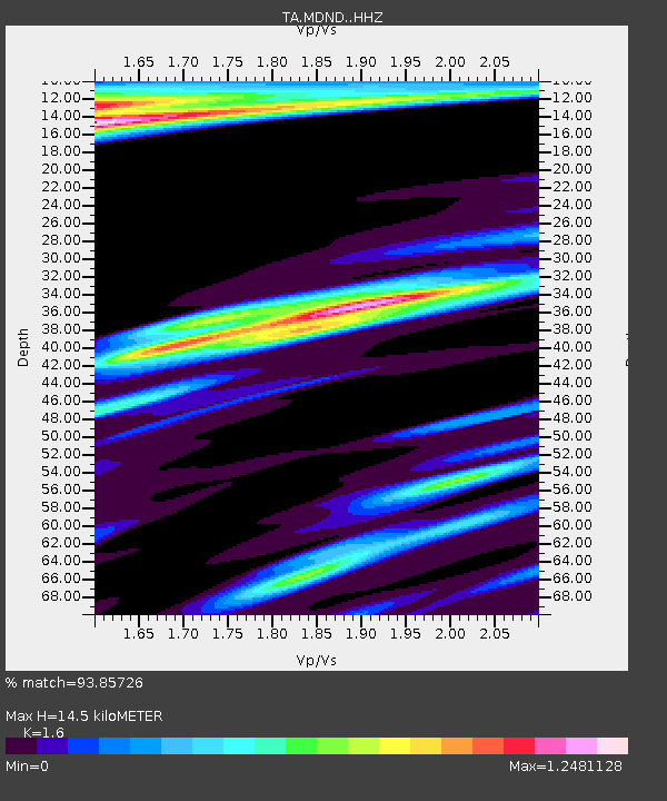
| Estimated Moho Depth: |
14.5 km |
| Estimated Crust Vp/Vs: |
1.60 |
| Assumed Crust Vp: |
6.53 km/s |
| Estimated Crust Vs: |
4.082 km/s |
| Estimated Crust Poisson's Ratio: |
0.18 |
|
| Radial Match: |
93.85726 % |
| Radial Bump: |
276 |
| Transverse Match: |
86.95112 % |
| Transverse Bump: |
400 |
| SOD ConfigId: |
11737051 |
| Insert Time: |
2019-04-25 09:22:40.411 +0000 |
| GWidth: |
2.5 |
| Max Bumps: |
400 |
| Tol: |
0.001 |
|

Signal To Noise
| Channel | StoN | STA | LTA |
| TA:MDND: :HHZ:20160829T04:41:59.380Z | 4.004639 | 4.2373048E-7 | 1.05809896E-7 |
| TA:MDND: :HHN:20160829T04:41:59.380Z | 2.0053818 | 4.8130687E-7 | 2.4000758E-7 |
| TA:MDND: :HHE:20160829T04:41:59.380Z | 0.8765017 | 2.3105439E-7 | 2.6360976E-7 |
| Arrivals |
| Ps | 1.4 SECOND |
| PpPs | 5.6 SECOND |
| PsPs/PpSs | 7.0 SECOND |


