You are here: Home > Network List > TJ - Tajikistan National Seismic Network Stations List
> Station IGRN Igron, Tajikistan > Earthquake Result Viewer
IGRN Igron, Tajikistan - Earthquake Result Viewer
| Earthquake location: |
North Of Ascension Island |
| Earthquake latitude/longitude: |
-0.0/-17.8 |
| Earthquake time(UTC): |
2016/08/29 (242) 04:29:57 GMT |
| Earthquake Depth: |
10 km |
| Earthquake Magnitude: |
7.1 MWW, 7.1 MWC, 7.4 MI |
| Earthquake Catalog/Contributor: |
NEIC PDE/NEIC COMCAT |
|
| Network: |
TJ Tajikistan National Seismic Network |
| Station: |
IGRN Igron, Tajikistan |
| Lat/Lon: |
38.22 N/69.33 E |
| Elevation: |
1284 m |
|
| Distance: |
87.8 deg |
| Az: |
51.931 deg |
| Baz: |
268.21 deg |
| Ray Param: |
0.04306896 |
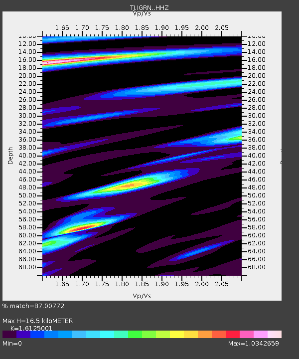
| Estimated Moho Depth: |
16.5 km |
| Estimated Crust Vp/Vs: |
1.61 |
| Assumed Crust Vp: |
6.483 km/s |
| Estimated Crust Vs: |
4.02 km/s |
| Estimated Crust Poisson's Ratio: |
0.19 |
|
| Radial Match: |
87.00772 % |
| Radial Bump: |
400 |
| Transverse Match: |
84.46255 % |
| Transverse Bump: |
400 |
| SOD ConfigId: |
11737051 |
| Insert Time: |
2019-04-25 09:23:05.202 +0000 |
| GWidth: |
2.5 |
| Max Bumps: |
400 |
| Tol: |
0.001 |
|

Signal To Noise
| Channel | StoN | STA | LTA |
| TJ:IGRN: :HHZ:20160829T04:42:15.520015Z | 2.611429 | 4.873531E-7 | 1.8662314E-7 |
| TJ:IGRN: :HHN:20160829T04:42:15.520015Z | 1.0633351 | 2.1381544E-7 | 2.0108003E-7 |
| TJ:IGRN: :HHE:20160829T04:42:15.520015Z | 1.6120809 | 2.5193143E-7 | 1.5627715E-7 |
| Arrivals |
| Ps | 1.6 SECOND |
| PpPs | 6.5 SECOND |
| PsPs/PpSs | 8.1 SECOND |


