You are here: Home > Network List > YW16 - IRIS Community Wavefield Experiment in Oklahoma Stations List
> Station 509 Wavefields Community Experiment, OK, USA > Earthquake Result Viewer
509 Wavefields Community Experiment, OK, USA - Earthquake Result Viewer
| Earthquake location: |
North Of Ascension Island |
| Earthquake latitude/longitude: |
-0.0/-17.8 |
| Earthquake time(UTC): |
2016/08/29 (242) 04:29:57 GMT |
| Earthquake Depth: |
10 km |
| Earthquake Magnitude: |
7.1 MWW, 7.1 MWC, 7.4 MI |
| Earthquake Catalog/Contributor: |
NEIC PDE/NEIC COMCAT |
|
| Network: |
YW IRIS Community Wavefield Experiment in Oklahoma |
| Station: |
509 Wavefields Community Experiment, OK, USA |
| Lat/Lon: |
36.61 N/97.70 W |
| Elevation: |
319 m |
|
| Distance: |
81.9 deg |
| Az: |
306.864 deg |
| Baz: |
96.094 deg |
| Ray Param: |
0.04726702 |
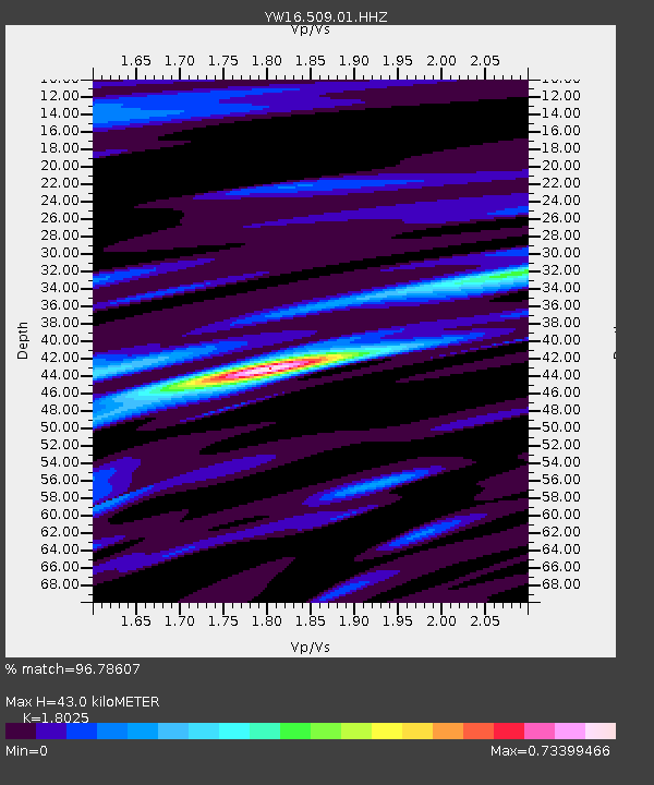
| Estimated Moho Depth: |
43.0 km |
| Estimated Crust Vp/Vs: |
1.80 |
| Assumed Crust Vp: |
6.483 km/s |
| Estimated Crust Vs: |
3.596 km/s |
| Estimated Crust Poisson's Ratio: |
0.28 |
|
| Radial Match: |
96.78607 % |
| Radial Bump: |
289 |
| Transverse Match: |
88.14902 % |
| Transverse Bump: |
400 |
| SOD ConfigId: |
11737051 |
| Insert Time: |
2019-04-25 09:24:05.312 +0000 |
| GWidth: |
2.5 |
| Max Bumps: |
400 |
| Tol: |
0.001 |
|

Signal To Noise
| Channel | StoN | STA | LTA |
| YW:509:01:HHZ:20160829T04:41:45.960017Z | 2.9373376 | 2.4303796E-7 | 8.27409E-8 |
| YW:509:01:HH1:20160829T04:41:45.960017Z | 1.1702127 | 1.0988358E-7 | 9.390052E-8 |
| YW:509:01:HH2:20160829T04:41:45.960017Z | 1.463393 | 1.43643E-7 | 9.815751E-8 |
| Arrivals |
| Ps | 5.5 SECOND |
| PpPs | 18 SECOND |
| PsPs/PpSs | 24 SECOND |


