You are here: Home > Network List > YX16 - Raton Basin UNM Broadband Network Stations List
> Station UNM4 NW Corner of NM Stations > Earthquake Result Viewer
UNM4 NW Corner of NM Stations - Earthquake Result Viewer
| Earthquake location: |
North Of Ascension Island |
| Earthquake latitude/longitude: |
-0.0/-17.8 |
| Earthquake time(UTC): |
2016/08/29 (242) 04:29:57 GMT |
| Earthquake Depth: |
10 km |
| Earthquake Magnitude: |
7.1 MWW, 7.1 MWC, 7.4 MI |
| Earthquake Catalog/Contributor: |
NEIC PDE/NEIC COMCAT |
|
| Network: |
YX Raton Basin UNM Broadband Network |
| Station: |
UNM4 NW Corner of NM Stations |
| Lat/Lon: |
36.99 N/105.06 W |
| Elevation: |
2784 m |
|
| Distance: |
87.8 deg |
| Az: |
306.841 deg |
| Baz: |
91.7 deg |
| Ray Param: |
0.04305473 |
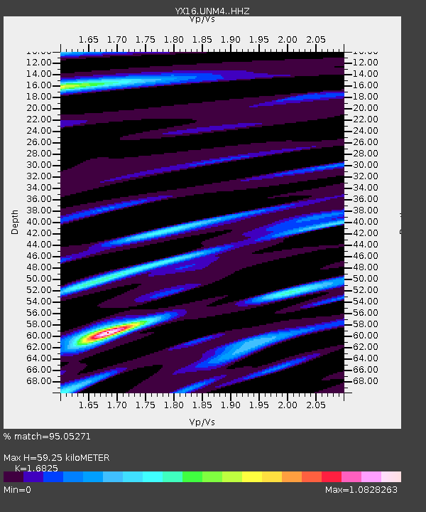
| Estimated Moho Depth: |
59.25 km |
| Estimated Crust Vp/Vs: |
1.68 |
| Assumed Crust Vp: |
6.316 km/s |
| Estimated Crust Vs: |
3.754 km/s |
| Estimated Crust Poisson's Ratio: |
0.23 |
|
| Radial Match: |
95.05271 % |
| Radial Bump: |
276 |
| Transverse Match: |
87.4924 % |
| Transverse Bump: |
381 |
| SOD ConfigId: |
11737051 |
| Insert Time: |
2019-04-25 09:24:16.826 +0000 |
| GWidth: |
2.5 |
| Max Bumps: |
400 |
| Tol: |
0.001 |
|

Signal To Noise
| Channel | StoN | STA | LTA |
| YX:UNM4: :HHZ:20160829T04:42:15.60998Z | 0.9412191 | 9.406161E-8 | 9.993594E-8 |
| YX:UNM4: :HHN:20160829T04:42:15.60998Z | 0.62237823 | 4.6987115E-8 | 7.5496075E-8 |
| YX:UNM4: :HHE:20160829T04:42:15.60998Z | 0.61939394 | 5.4255114E-8 | 8.7593875E-8 |
| Arrivals |
| Ps | 6.5 SECOND |
| PpPs | 25 SECOND |
| PsPs/PpSs | 31 SECOND |


