You are here: Home > Network List > US - United States National Seismic Network Stations List
> Station RSSD Black Hills, South Dakota, USA > Earthquake Result Viewer
RSSD Black Hills, South Dakota, USA - Earthquake Result Viewer
| Earthquake location: |
Near Coast Of Peru |
| Earthquake latitude/longitude: |
-16.3/-73.6 |
| Earthquake time(UTC): |
2001/06/23 (174) 20:33:14 GMT |
| Earthquake Depth: |
33 km |
| Earthquake Magnitude: |
6.7 MB, 8.2 MS, 8.4 MW, 7.8 ME |
| Earthquake Catalog/Contributor: |
WHDF/NEIC |
|
| Network: |
US United States National Seismic Network |
| Station: |
RSSD Black Hills, South Dakota, USA |
| Lat/Lon: |
44.12 N/104.04 W |
| Elevation: |
2060 m |
|
| Distance: |
66.2 deg |
| Az: |
336.53 deg |
| Baz: |
147.918 deg |
| Ray Param: |
0.057720654 |
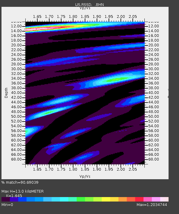
| Estimated Moho Depth: |
13.0 km |
| Estimated Crust Vp/Vs: |
1.64 |
| Assumed Crust Vp: |
6.242 km/s |
| Estimated Crust Vs: |
3.795 km/s |
| Estimated Crust Poisson's Ratio: |
0.21 |
|
| Radial Match: |
90.69039 % |
| Radial Bump: |
400 |
| Transverse Match: |
97.59479 % |
| Transverse Bump: |
344 |
| SOD ConfigId: |
110165 |
| Insert Time: |
2010-03-05 06:32:42.008 +0000 |
| GWidth: |
2.5 |
| Max Bumps: |
400 |
| Tol: |
0.001 |
|
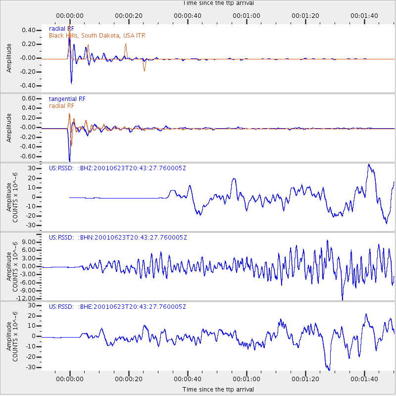
Signal To Noise
| Channel | StoN | STA | LTA |
| US:RSSD: :BHN:20010623T20:43:27.760005Z | 5.345721 | 2.5707547E-7 | 4.808995E-8 |
| US:RSSD: :BHE:20010623T20:43:27.760005Z | 12.474001 | 1.5672975E-6 | 1.2564513E-7 |
| US:RSSD: :BHZ:20010623T20:43:27.760005Z | 21.179832 | 3.1536958E-6 | 1.4890088E-7 |
| Arrivals |
| Ps | 1.4 SECOND |
| PpPs | 5.3 SECOND |
| PsPs/PpSs | 6.7 SECOND |


