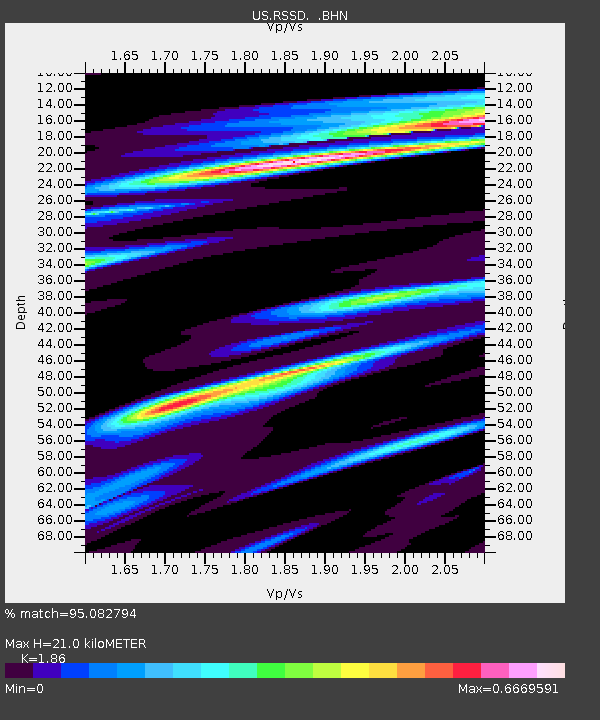
RSSD Black Hills, South Dakota, USA - Earthquake Result Viewer

Earthquake location: Rat Islands, Aleutian Islands
Earthquake latitude/longitude: 51.1/178.6
Earthquake time(UTC): 2003/11/17 (321) 06:43:06 GMT
Earthquake Depth: 33 km
Earthquake Magnitude: 6.2 MB, 7.2 MS, 7.8 MW, 7.7 MW
Earthquake Catalog/Contributor: WHDF/NEIC
Network: US United States National Seismic Network
Station: RSSD Black Hills, South Dakota, USA
Lat/Lon: 44.12 N/104.04 W
Elevation: 2060 m
Distance: 50.3 deg
Az: 65.91 deg
Baz: 307.02 deg
Ray Param: 0.06806936
Estimated Moho Depth: 21.0 km
Estimated Crust Vp/Vs: 1.86
Assumed Crust Vp: 6.242 km/s
Estimated Crust Vs: 3.356 km/s
Estimated Crust Poisson's Ratio: 0.30
Radial Match: 95.082794 %
Radial Bump: 364
Transverse Match: 83.55548 %
Transverse Bump: 400
SOD ConfigId: 110165
Insert Time: 2010-03-05 06:32:54.242 +0000
GWidth: 2.5
Max Bumps: 400
Tol: 0.001

Signal To Noise

ChannelStoNSTALTA
US:RSSD: :BHN:20031117T06:51:29.746014Z1.31918794.179272E-73.1680645E-7
US:RSSD: :BHE:20031117T06:51:29.746014Z1.5544045.3060603E-73.4135658E-7
US:RSSD: :BHZ:20031117T06:51:29.746014Z1.89693277.05676E-73.7200894E-7
Arrivals
Ps3.0 SECOND
PpPs9.1 SECOND
PsPs/PpSs12 SECOND