You are here: Home > Network List > US - United States National Seismic Network Stations List
> Station VBMS Vicksburg, Mississippi > Earthquake Result Viewer
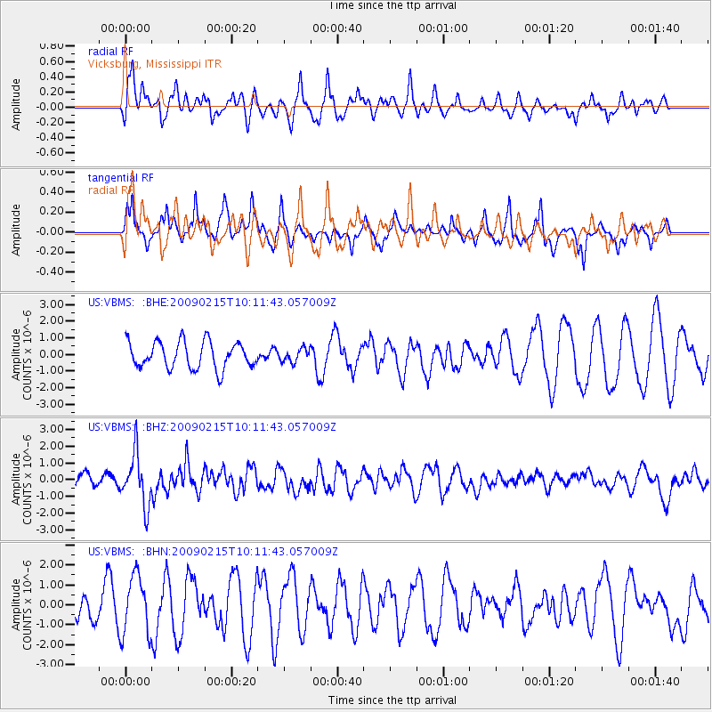
VBMS Vicksburg, Mississippi - Earthquake Result Viewer
*The percent match for this event was below the threshold and hence no stack was calculated.
| Earthquake location: |
Near Coast Of Northern Peru |
| Earthquake latitude/longitude: |
-5.9/-80.9 |
| Earthquake time(UTC): |
2009/02/15 (046) 10:04:49 GMT |
| Earthquake Depth: |
21 km |
| Earthquake Magnitude: |
5.8 MB, 5.7 MS, 6.1 MW, 6.1 MW |
| Earthquake Catalog/Contributor: |
WHDF/NEIC |
|
| Network: |
US United States National Seismic Network |
| Station: |
VBMS Vicksburg, Mississippi |
| Lat/Lon: |
32.22 N/90.52 W |
| Elevation: |
0.0 m |
|
| Distance: |
39.0 deg |
| Az: |
346.97 deg |
| Baz: |
164.656 deg |
| Ray Param: |
$rayparam |
*The percent match for this event was below the threshold and hence was not used in the summary stack. |
|
| Radial Match: |
57.64989 % |
| Radial Bump: |
400 |
| Transverse Match: |
60.004894 % |
| Transverse Bump: |
344 |
| SOD ConfigId: |
2658 |
| Insert Time: |
2010-03-05 06:33:09.903 +0000 |
| GWidth: |
2.5 |
| Max Bumps: |
400 |
| Tol: |
0.001 |
|
Signal To Noise
| Channel | StoN | STA | LTA |
| US:VBMS: :BHZ:20090215T10:11:43.057009Z | 3.928601 | 1.548389E-6 | 3.9413243E-7 |
| US:VBMS: :BHN:20090215T10:11:43.057009Z | 2.6543522 | 1.478647E-6 | 5.570651E-7 |
| US:VBMS: :BHE:20090215T10:11:43.057009Z | 0.49989265 | 3.9908556E-7 | 7.983425E-7 |
| Arrivals |
| Ps | |
| PpPs | |
| PsPs/PpSs | |


