You are here: Home > Network List > AK - Alaska Regional Network Stations List
> Station SLK Skilak Lake, AK, USA > Earthquake Result Viewer
SLK Skilak Lake, AK, USA - Earthquake Result Viewer
| Earthquake location: |
New Ireland Region, P.N.G. |
| Earthquake latitude/longitude: |
-3.7/152.8 |
| Earthquake time(UTC): |
2016/08/31 (244) 03:11:36 GMT |
| Earthquake Depth: |
499 km |
| Earthquake Magnitude: |
6.7 MO |
| Earthquake Catalog/Contributor: |
NEIC PDE/NEIC ALERT |
|
| Network: |
AK Alaska Regional Network |
| Station: |
SLK Skilak Lake, AK, USA |
| Lat/Lon: |
60.51 N/150.22 W |
| Elevation: |
655 m |
|
| Distance: |
77.7 deg |
| Az: |
25.13 deg |
| Baz: |
238.935 deg |
| Ray Param: |
0.048653465 |
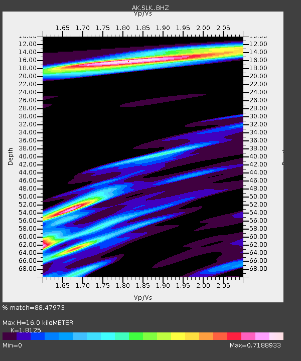
| Estimated Moho Depth: |
16.0 km |
| Estimated Crust Vp/Vs: |
1.81 |
| Assumed Crust Vp: |
6.302 km/s |
| Estimated Crust Vs: |
3.477 km/s |
| Estimated Crust Poisson's Ratio: |
0.28 |
|
| Radial Match: |
88.47973 % |
| Radial Bump: |
400 |
| Transverse Match: |
80.20154 % |
| Transverse Bump: |
400 |
| SOD ConfigId: |
11737051 |
| Insert Time: |
2019-04-25 09:37:47.945 +0000 |
| GWidth: |
2.5 |
| Max Bumps: |
400 |
| Tol: |
0.001 |
|

Signal To Noise
| Channel | StoN | STA | LTA |
| AK:SLK: :BHZ:20160831T03:22:09.468018Z | 32.72736 | 2.6909875E-6 | 8.222439E-8 |
| AK:SLK: :BHN:20160831T03:22:09.468018Z | 5.97422 | 6.5830005E-7 | 1.1019012E-7 |
| AK:SLK: :BHE:20160831T03:22:09.468018Z | 4.928208 | 1.5871441E-6 | 3.2205298E-7 |
| Arrivals |
| Ps | 2.1 SECOND |
| PpPs | 7.0 SECOND |
| PsPs/PpSs | 9.1 SECOND |


