You are here: Home > Network List > US - United States National Seismic Network Stations List
> Station VBMS Vicksburg, Mississippi > Earthquake Result Viewer
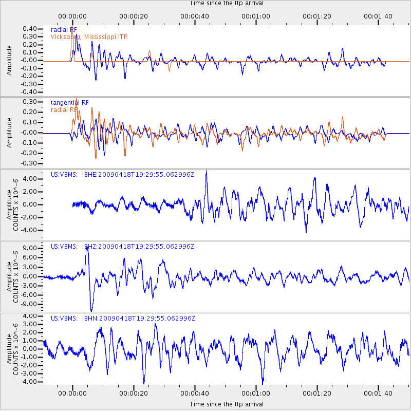
VBMS Vicksburg, Mississippi - Earthquake Result Viewer
*The percent match for this event was below the threshold and hence no stack was calculated.
| Earthquake location: |
Kuril Islands |
| Earthquake latitude/longitude: |
46.0/151.4 |
| Earthquake time(UTC): |
2009/04/18 (108) 19:17:58 GMT |
| Earthquake Depth: |
35 km |
| Earthquake Magnitude: |
6.3 MB, 6.3 MS, 6.6 MW, 6.4 MW |
| Earthquake Catalog/Contributor: |
WHDF/NEIC |
|
| Network: |
US United States National Seismic Network |
| Station: |
VBMS Vicksburg, Mississippi |
| Lat/Lon: |
32.22 N/90.52 W |
| Elevation: |
0.0 m |
|
| Distance: |
84.1 deg |
| Az: |
48.764 deg |
| Baz: |
321.811 deg |
| Ray Param: |
$rayparam |
*The percent match for this event was below the threshold and hence was not used in the summary stack. |
|
| Radial Match: |
88.92327 % |
| Radial Bump: |
400 |
| Transverse Match: |
78.01289 % |
| Transverse Bump: |
400 |
| SOD ConfigId: |
2658 |
| Insert Time: |
2010-03-05 06:33:29.974 +0000 |
| GWidth: |
2.5 |
| Max Bumps: |
400 |
| Tol: |
0.001 |
|
Signal To Noise
| Channel | StoN | STA | LTA |
| US:VBMS: :BHZ:20090418T19:29:55.062996Z | 13.130475 | 3.2224634E-6 | 2.4541865E-7 |
| US:VBMS: :BHN:20090418T19:29:55.062996Z | 1.2177308 | 5.7201055E-7 | 4.6973486E-7 |
| US:VBMS: :BHE:20090418T19:29:55.062996Z | 0.7862148 | 4.176085E-7 | 5.311634E-7 |
| Arrivals |
| Ps | |
| PpPs | |
| PsPs/PpSs | |


