You are here: Home > Network List > AV - Alaska Volcano Observatory Stations List
> Station SPCR Ckakachatna River, Mount Spurr, Alaska > Earthquake Result Viewer
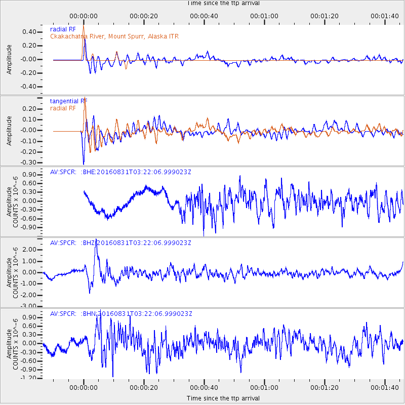
SPCR Ckakachatna River, Mount Spurr, Alaska - Earthquake Result Viewer
*The percent match for this event was below the threshold and hence no stack was calculated.
| Earthquake location: |
New Ireland Region, P.N.G. |
| Earthquake latitude/longitude: |
-3.7/152.8 |
| Earthquake time(UTC): |
2016/08/31 (244) 03:11:36 GMT |
| Earthquake Depth: |
499 km |
| Earthquake Magnitude: |
6.7 MO |
| Earthquake Catalog/Contributor: |
NEIC PDE/NEIC ALERT |
|
| Network: |
AV Alaska Volcano Observatory |
| Station: |
SPCR Ckakachatna River, Mount Spurr, Alaska |
| Lat/Lon: |
61.20 N/152.21 W |
| Elevation: |
984 m |
|
| Distance: |
77.2 deg |
| Az: |
24.001 deg |
| Baz: |
236.958 deg |
| Ray Param: |
$rayparam |
*The percent match for this event was below the threshold and hence was not used in the summary stack. |
|
| Radial Match: |
60.110153 % |
| Radial Bump: |
400 |
| Transverse Match: |
58.5398 % |
| Transverse Bump: |
400 |
| SOD ConfigId: |
11737051 |
| Insert Time: |
2019-04-25 09:38:55.659 +0000 |
| GWidth: |
2.5 |
| Max Bumps: |
400 |
| Tol: |
0.001 |
|
Signal To Noise
| Channel | StoN | STA | LTA |
| AV:SPCR: :BHZ:20160831T03:22:06.999023Z | 6.7925043 | 1.2459882E-6 | 1.8343576E-7 |
| AV:SPCR: :BHN:20160831T03:22:06.999023Z | 2.5669827 | 3.9389093E-7 | 1.534451E-7 |
| AV:SPCR: :BHE:20160831T03:22:06.999023Z | 0.93294054 | 2.9769816E-7 | 3.1909659E-7 |
| Arrivals |
| Ps | |
| PpPs | |
| PsPs/PpSs | |


