You are here: Home > Network List > US - United States National Seismic Network Stations List
> Station VBMS Vicksburg, Mississippi > Earthquake Result Viewer
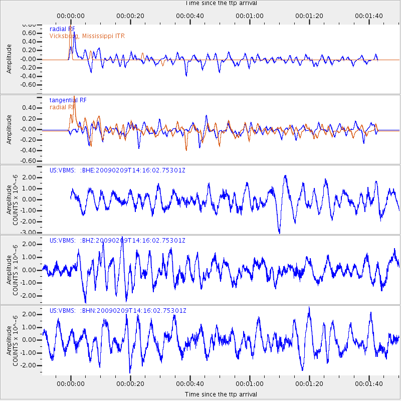
VBMS Vicksburg, Mississippi - Earthquake Result Viewer
*The percent match for this event was below the threshold and hence no stack was calculated.
| Earthquake location: |
Near Coast Of Northern Peru |
| Earthquake latitude/longitude: |
-6.6/-81.2 |
| Earthquake time(UTC): |
2009/02/09 (040) 14:09:02 GMT |
| Earthquake Depth: |
15 km |
| Earthquake Magnitude: |
5.5 MB, 5.5 MS, 6.0 MW, 5.9 MW |
| Earthquake Catalog/Contributor: |
WHDF/NEIC |
|
| Network: |
US United States National Seismic Network |
| Station: |
VBMS Vicksburg, Mississippi |
| Lat/Lon: |
32.22 N/90.52 W |
| Elevation: |
0.0 m |
|
| Distance: |
39.6 deg |
| Az: |
347.497 deg |
| Baz: |
165.3 deg |
| Ray Param: |
$rayparam |
*The percent match for this event was below the threshold and hence was not used in the summary stack. |
|
| Radial Match: |
64.94983 % |
| Radial Bump: |
400 |
| Transverse Match: |
49.958477 % |
| Transverse Bump: |
400 |
| SOD ConfigId: |
2658 |
| Insert Time: |
2010-03-05 06:33:54.807 +0000 |
| GWidth: |
2.5 |
| Max Bumps: |
400 |
| Tol: |
0.001 |
|
Signal To Noise
| Channel | StoN | STA | LTA |
| US:VBMS: :BHZ:20090209T14:16:02.75301Z | 2.7419116 | 8.939649E-7 | 3.260371E-7 |
| US:VBMS: :BHN:20090209T14:16:02.75301Z | 1.1372764 | 5.3326437E-7 | 4.68896E-7 |
| US:VBMS: :BHE:20090209T14:16:02.75301Z | 1.329531 | 7.643157E-7 | 5.748762E-7 |
| Arrivals |
| Ps | |
| PpPs | |
| PsPs/PpSs | |


