You are here: Home > Network List > IN - National Seismic Network of India Stations List
> Station SHL Shillong, Meghalaya, India > Earthquake Result Viewer
SHL Shillong, Meghalaya, India - Earthquake Result Viewer
| Earthquake location: |
New Ireland Region, P.N.G. |
| Earthquake latitude/longitude: |
-3.7/152.8 |
| Earthquake time(UTC): |
2016/08/31 (244) 03:11:36 GMT |
| Earthquake Depth: |
499 km |
| Earthquake Magnitude: |
6.7 MO |
| Earthquake Catalog/Contributor: |
NEIC PDE/NEIC ALERT |
|
| Network: |
IN National Seismic Network of India |
| Station: |
SHL Shillong, Meghalaya, India |
| Lat/Lon: |
25.57 N/91.86 E |
| Elevation: |
2.0 m |
|
| Distance: |
65.8 deg |
| Az: |
300.033 deg |
| Baz: |
106.951 deg |
| Ray Param: |
0.0563057 |
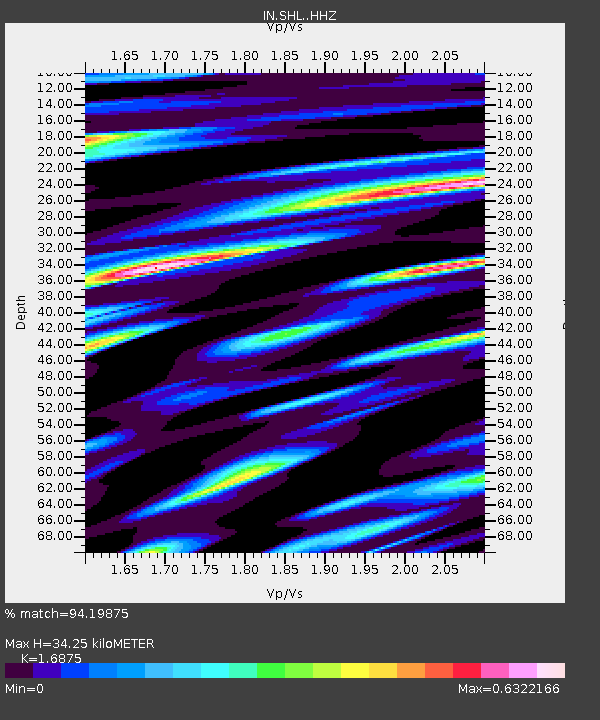
| Estimated Moho Depth: |
34.25 km |
| Estimated Crust Vp/Vs: |
1.69 |
| Assumed Crust Vp: |
6.273 km/s |
| Estimated Crust Vs: |
3.717 km/s |
| Estimated Crust Poisson's Ratio: |
0.23 |
|
| Radial Match: |
94.19875 % |
| Radial Bump: |
273 |
| Transverse Match: |
78.327934 % |
| Transverse Bump: |
400 |
| SOD ConfigId: |
11737051 |
| Insert Time: |
2019-04-25 09:41:43.895 +0000 |
| GWidth: |
2.5 |
| Max Bumps: |
400 |
| Tol: |
0.001 |
|

Signal To Noise
| Channel | StoN | STA | LTA |
| IN:SHL: :HHZ:20160831T03:21:00.140015Z | 54.158848 | 5.516758E-6 | 1.0186254E-7 |
| IN:SHL: :HHN:20160831T03:21:00.140015Z | 10.003748 | 1.134265E-6 | 1.13384E-7 |
| IN:SHL: :HHE:20160831T03:21:00.140015Z | 33.864685 | 3.2122125E-6 | 9.485434E-8 |
| Arrivals |
| Ps | 3.9 SECOND |
| PpPs | 14 SECOND |
| PsPs/PpSs | 18 SECOND |


