You are here: Home > Network List > S - Seismographs in Schools Projects Stations List
> Station AUCAS Cummins Area School, SA > Earthquake Result Viewer
AUCAS Cummins Area School, SA - Earthquake Result Viewer
| Earthquake location: |
New Ireland Region, P.N.G. |
| Earthquake latitude/longitude: |
-3.7/152.8 |
| Earthquake time(UTC): |
2016/08/31 (244) 03:11:36 GMT |
| Earthquake Depth: |
499 km |
| Earthquake Magnitude: |
6.7 MO |
| Earthquake Catalog/Contributor: |
NEIC PDE/NEIC ALERT |
|
| Network: |
S Seismographs in Schools Projects |
| Station: |
AUCAS Cummins Area School, SA |
| Lat/Lon: |
34.26 S/135.72 E |
| Elevation: |
72 m |
|
| Distance: |
34.3 deg |
| Az: |
205.541 deg |
| Baz: |
31.301 deg |
| Ray Param: |
0.07548658 |
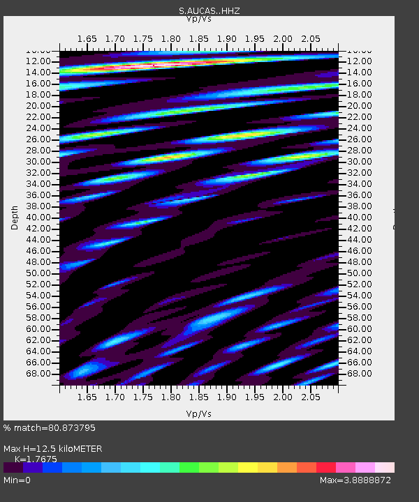
| Estimated Moho Depth: |
12.5 km |
| Estimated Crust Vp/Vs: |
1.77 |
| Assumed Crust Vp: |
6.134 km/s |
| Estimated Crust Vs: |
3.47 km/s |
| Estimated Crust Poisson's Ratio: |
0.26 |
|
| Radial Match: |
80.873795 % |
| Radial Bump: |
400 |
| Transverse Match: |
68.33819 % |
| Transverse Bump: |
400 |
| SOD ConfigId: |
11737051 |
| Insert Time: |
2019-04-25 09:43:48.086 +0000 |
| GWidth: |
2.5 |
| Max Bumps: |
400 |
| Tol: |
0.001 |
|

Signal To Noise
| Channel | StoN | STA | LTA |
| S:AUCAS: :HHZ:20160831T03:17:09.649994Z | 7.464346 | 5.713496E-6 | 7.654383E-7 |
| S:AUCAS: :HHN:20160831T03:17:09.649994Z | 9.292524 | 7.233866E-6 | 7.7846084E-7 |
| S:AUCAS: :HHE:20160831T03:17:09.649994Z | 7.6922517 | 4.6556884E-6 | 6.052439E-7 |
| Arrivals |
| Ps | 1.7 SECOND |
| PpPs | 5.3 SECOND |
| PsPs/PpSs | 7.0 SECOND |


