You are here: Home > Network List > US - United States National Seismic Network Stations List
> Station WCI Wyandotte Cave, Indiana, USA > Earthquake Result Viewer
WCI Wyandotte Cave, Indiana, USA - Earthquake Result Viewer
| Earthquake location: |
Near Coast Of Northern Chile |
| Earthquake latitude/longitude: |
-27.4/-70.8 |
| Earthquake time(UTC): |
2004/08/27 (240) 00:43:54 GMT |
| Earthquake Depth: |
30 km |
| Earthquake Magnitude: |
5.8 MB, 5.4 MS, 5.9 MW, 5.8 MW |
| Earthquake Catalog/Contributor: |
WHDF/NEIC |
|
| Network: |
US United States National Seismic Network |
| Station: |
WCI Wyandotte Cave, Indiana, USA |
| Lat/Lon: |
38.23 N/86.29 W |
| Elevation: |
500 m |
|
| Distance: |
66.9 deg |
| Az: |
346.782 deg |
| Baz: |
165.044 deg |
| Ray Param: |
0.057264734 |
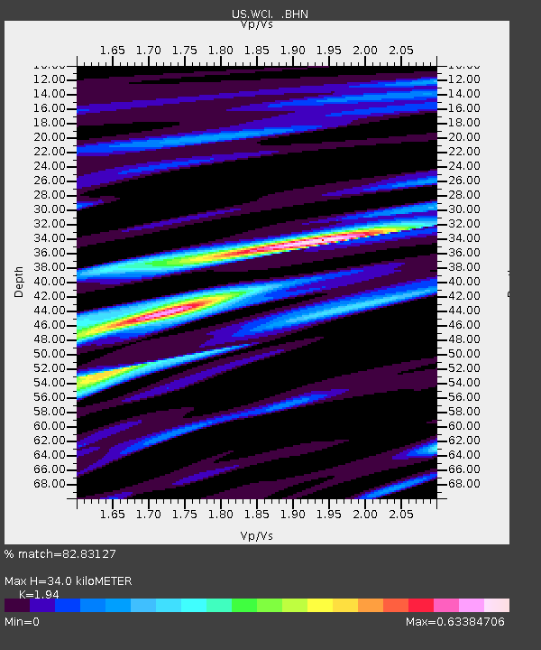
| Estimated Moho Depth: |
34.0 km |
| Estimated Crust Vp/Vs: |
1.94 |
| Assumed Crust Vp: |
6.444 km/s |
| Estimated Crust Vs: |
3.322 km/s |
| Estimated Crust Poisson's Ratio: |
0.32 |
|
| Radial Match: |
82.83127 % |
| Radial Bump: |
400 |
| Transverse Match: |
63.92187 % |
| Transverse Bump: |
400 |
| SOD ConfigId: |
110177 |
| Insert Time: |
2010-03-05 06:34:19.932 +0000 |
| GWidth: |
2.5 |
| Max Bumps: |
400 |
| Tol: |
0.001 |
|
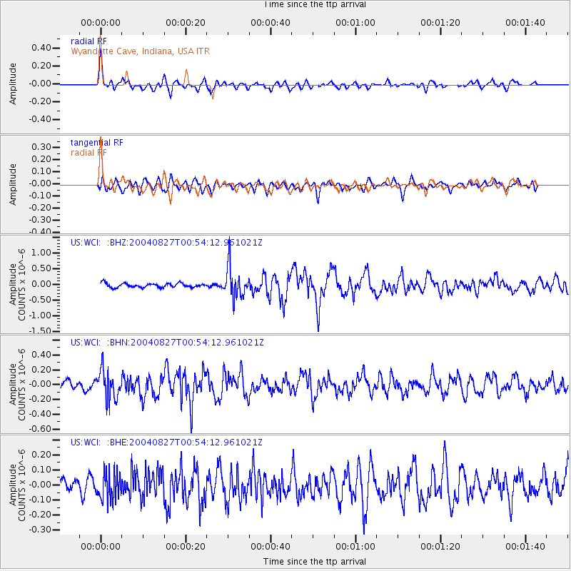
Signal To Noise
| Channel | StoN | STA | LTA |
| US:WCI: :BHN:20040827T00:54:12.961021Z | 3.2109523 | 1.9524482E-7 | 6.0805895E-8 |
| US:WCI: :BHE:20040827T00:54:12.961021Z | 1.6765562 | 8.8626976E-8 | 5.2862514E-8 |
| US:WCI: :BHZ:20040827T00:54:12.961021Z | 7.5957994 | 4.9643825E-7 | 6.535694E-8 |
| Arrivals |
| Ps | 5.1 SECOND |
| PpPs | 15 SECOND |
| PsPs/PpSs | 20 SECOND |


