You are here: Home > Network List > TA - USArray Transportable Network (new EarthScope stations) Stations List
> Station G21K Allakaket, AK, USA > Earthquake Result Viewer
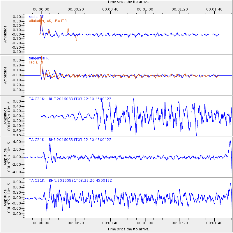
G21K Allakaket, AK, USA - Earthquake Result Viewer
*The percent match for this event was below the threshold and hence no stack was calculated.
| Earthquake location: |
New Ireland Region, P.N.G. |
| Earthquake latitude/longitude: |
-3.7/152.8 |
| Earthquake time(UTC): |
2016/08/31 (244) 03:11:36 GMT |
| Earthquake Depth: |
499 km |
| Earthquake Magnitude: |
6.7 MO |
| Earthquake Catalog/Contributor: |
NEIC PDE/NEIC ALERT |
|
| Network: |
TA USArray Transportable Network (new EarthScope stations) |
| Station: |
G21K Allakaket, AK, USA |
| Lat/Lon: |
66.52 N/153.51 W |
| Elevation: |
446 m |
|
| Distance: |
79.7 deg |
| Az: |
19.163 deg |
| Baz: |
234.827 deg |
| Ray Param: |
$rayparam |
*The percent match for this event was below the threshold and hence was not used in the summary stack. |
|
| Radial Match: |
76.089294 % |
| Radial Bump: |
341 |
| Transverse Match: |
61.7078 % |
| Transverse Bump: |
400 |
| SOD ConfigId: |
11737051 |
| Insert Time: |
2019-04-25 09:44:18.218 +0000 |
| GWidth: |
2.5 |
| Max Bumps: |
400 |
| Tol: |
0.001 |
|
Signal To Noise
| Channel | StoN | STA | LTA |
| TA:G21K: :BHZ:20160831T03:22:20.450012Z | 14.22176 | 1.1744991E-6 | 8.258465E-8 |
| TA:G21K: :BHN:20160831T03:22:20.450012Z | 4.489955 | 2.4027912E-7 | 5.3514817E-8 |
| TA:G21K: :BHE:20160831T03:22:20.450012Z | 3.8579721 | 2.516427E-7 | 6.522667E-8 |
| Arrivals |
| Ps | |
| PpPs | |
| PsPs/PpSs | |


