You are here: Home > Network List > TA - USArray Transportable Network (new EarthScope stations) Stations List
> Station G22K Bettles, AK, USA > Earthquake Result Viewer
G22K Bettles, AK, USA - Earthquake Result Viewer

| Earthquake location: |
New Ireland Region, P.N.G. |
| Earthquake latitude/longitude: |
-3.7/152.8 |
| Earthquake time(UTC): |
2016/08/31 (244) 03:11:36 GMT |
| Earthquake Depth: |
499 km |
| Earthquake Magnitude: |
6.7 MO |
| Earthquake Catalog/Contributor: |
NEIC PDE/NEIC ALERT |
|
| Network: |
TA USArray Transportable Network (new EarthScope stations) |
| Station: |
G22K Bettles, AK, USA |
| Lat/Lon: |
66.92 N/151.51 W |
| Elevation: |
205 m |
|
| Distance: |
80.6 deg |
| Az: |
19.275 deg |
| Baz: |
236.68 deg |
| Ray Param: |
0.046688396 |
| Estimated Moho Depth: |
12.5 km |
| Estimated Crust Vp/Vs: |
1.60 |
| Assumed Crust Vp: |
6.577 km/s |
| Estimated Crust Vs: |
4.11 km/s |
| Estimated Crust Poisson's Ratio: |
0.18 |
|
| Radial Match: |
91.77339 % |
| Radial Bump: |
333 |
| Transverse Match: |
68.772026 % |
| Transverse Bump: |
400 |
| SOD ConfigId: |
11737051 |
| Insert Time: |
2019-04-25 09:44:19.108 +0000 |
| GWidth: |
2.5 |
| Max Bumps: |
400 |
| Tol: |
0.001 |
|
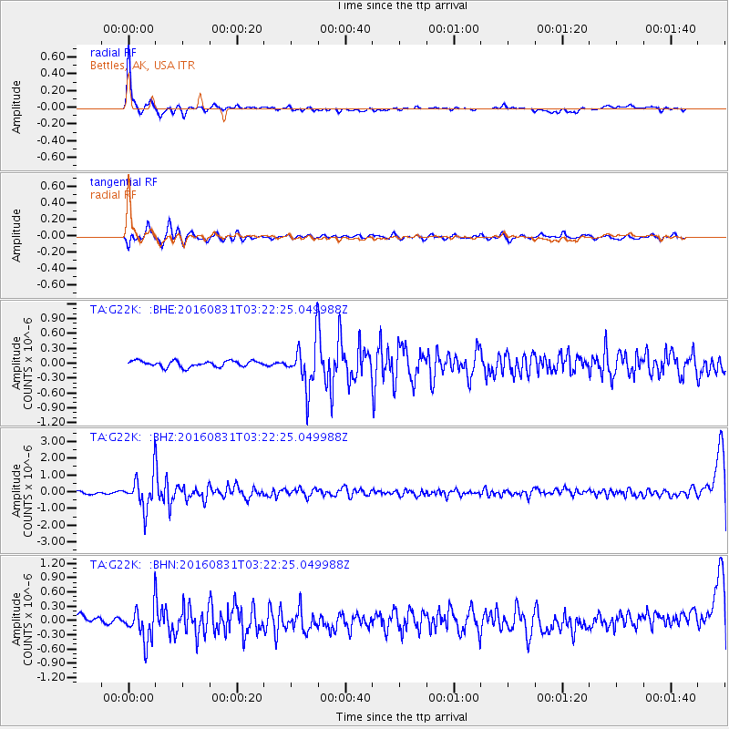
Signal To Noise
| Channel | StoN | STA | LTA |
| TA:G22K: :BHZ:20160831T03:22:25.049988Z | 12.340408 | 9.855966E-7 | 7.986742E-8 |
| TA:G22K: :BHN:20160831T03:22:25.049988Z | 4.8156023 | 3.6258464E-7 | 7.529373E-8 |
| TA:G22K: :BHE:20160831T03:22:25.049988Z | 7.3154664 | 4.4540053E-7 | 6.088477E-8 |
| Arrivals |
| Ps | 1.2 SECOND |
| PpPs | 4.8 SECOND |
| PsPs/PpSs | 6.0 SECOND |


