You are here: Home > Network List > TA - USArray Transportable Network (new EarthScope stations) Stations List
> Station G23K Bananza Creek, AK, USA > Earthquake Result Viewer
G23K Bananza Creek, AK, USA - Earthquake Result Viewer

| Earthquake location: |
New Ireland Region, P.N.G. |
| Earthquake latitude/longitude: |
-3.7/152.8 |
| Earthquake time(UTC): |
2016/08/31 (244) 03:11:36 GMT |
| Earthquake Depth: |
499 km |
| Earthquake Magnitude: |
6.7 MO |
| Earthquake Catalog/Contributor: |
NEIC PDE/NEIC ALERT |
|
| Network: |
TA USArray Transportable Network (new EarthScope stations) |
| Station: |
G23K Bananza Creek, AK, USA |
| Lat/Lon: |
66.71 N/150.02 W |
| Elevation: |
746 m |
|
| Distance: |
81.0 deg |
| Az: |
19.776 deg |
| Baz: |
238.122 deg |
| Ray Param: |
0.04643338 |
| Estimated Moho Depth: |
10.0 km |
| Estimated Crust Vp/Vs: |
1.80 |
| Assumed Crust Vp: |
6.577 km/s |
| Estimated Crust Vs: |
3.649 km/s |
| Estimated Crust Poisson's Ratio: |
0.28 |
|
| Radial Match: |
89.0997 % |
| Radial Bump: |
395 |
| Transverse Match: |
63.078693 % |
| Transverse Bump: |
400 |
| SOD ConfigId: |
11737051 |
| Insert Time: |
2019-04-25 09:44:21.044 +0000 |
| GWidth: |
2.5 |
| Max Bumps: |
400 |
| Tol: |
0.001 |
|
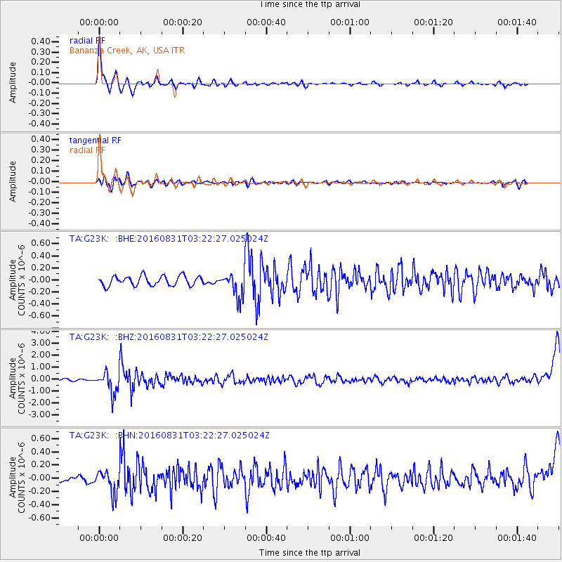
Signal To Noise
| Channel | StoN | STA | LTA |
| TA:G23K: :BHZ:20160831T03:22:27.025024Z | 12.6832075 | 8.781161E-7 | 6.9234545E-8 |
| TA:G23K: :BHN:20160831T03:22:27.025024Z | 3.665464 | 1.7573666E-7 | 4.7943907E-8 |
| TA:G23K: :BHE:20160831T03:22:27.025024Z | 2.5767403 | 2.045192E-7 | 7.937129E-8 |
| Arrivals |
| Ps | 1.3 SECOND |
| PpPs | 4.1 SECOND |
| PsPs/PpSs | 5.4 SECOND |


