You are here: Home > Network List > TA - USArray Transportable Network (new EarthScope stations) Stations List
> Station G27K Doyon Strip, AK, USA > Earthquake Result Viewer
G27K Doyon Strip, AK, USA - Earthquake Result Viewer
| Earthquake location: |
New Ireland Region, P.N.G. |
| Earthquake latitude/longitude: |
-3.7/152.8 |
| Earthquake time(UTC): |
2016/08/31 (244) 03:11:36 GMT |
| Earthquake Depth: |
499 km |
| Earthquake Magnitude: |
6.7 MO |
| Earthquake Catalog/Contributor: |
NEIC PDE/NEIC ALERT |
|
| Network: |
TA USArray Transportable Network (new EarthScope stations) |
| Station: |
G27K Doyon Strip, AK, USA |
| Lat/Lon: |
66.81 N/141.65 W |
| Elevation: |
686 m |
|
| Distance: |
84.0 deg |
| Az: |
21.256 deg |
| Baz: |
246.0 deg |
| Ray Param: |
0.044391777 |
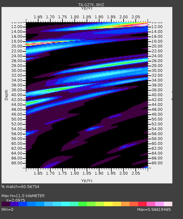
| Estimated Moho Depth: |
11.0 km |
| Estimated Crust Vp/Vs: |
2.10 |
| Assumed Crust Vp: |
6.577 km/s |
| Estimated Crust Vs: |
3.136 km/s |
| Estimated Crust Poisson's Ratio: |
0.35 |
|
| Radial Match: |
80.56754 % |
| Radial Bump: |
353 |
| Transverse Match: |
69.05981 % |
| Transverse Bump: |
400 |
| SOD ConfigId: |
11737051 |
| Insert Time: |
2019-04-25 09:44:22.145 +0000 |
| GWidth: |
2.5 |
| Max Bumps: |
400 |
| Tol: |
0.001 |
|

Signal To Noise
| Channel | StoN | STA | LTA |
| TA:G27K: :BHZ:20160831T03:22:42.025024Z | 11.979599 | 8.734941E-7 | 7.2915135E-8 |
| TA:G27K: :BHN:20160831T03:22:42.025024Z | 2.1773148 | 1.4364812E-7 | 6.59749E-8 |
| TA:G27K: :BHE:20160831T03:22:42.025024Z | 3.301711 | 2.3538453E-7 | 7.129168E-8 |
| Arrivals |
| Ps | 1.9 SECOND |
| PpPs | 5.1 SECOND |
| PsPs/PpSs | 6.9 SECOND |


