You are here: Home > Network List > US - United States National Seismic Network Stations List
> Station WCI Wyandotte Cave, Indiana, USA > Earthquake Result Viewer
WCI Wyandotte Cave, Indiana, USA - Earthquake Result Viewer

| Earthquake location: |
Hokkaido, Japan Region |
| Earthquake latitude/longitude: |
43.0/145.1 |
| Earthquake time(UTC): |
2004/11/28 (333) 18:32:14 GMT |
| Earthquake Depth: |
39 km |
| Earthquake Magnitude: |
6.4 MB, 6.7 MS, 7.0 MW, 7.0 MW |
| Earthquake Catalog/Contributor: |
WHDF/NEIC |
|
| Network: |
US United States National Seismic Network |
| Station: |
WCI Wyandotte Cave, Indiana, USA |
| Lat/Lon: |
38.23 N/86.29 W |
| Elevation: |
500 m |
|
| Distance: |
86.6 deg |
| Az: |
38.073 deg |
| Baz: |
324.944 deg |
| Ray Param: |
0.04384261 |
| Estimated Moho Depth: |
28.0 km |
| Estimated Crust Vp/Vs: |
1.95 |
| Assumed Crust Vp: |
6.444 km/s |
| Estimated Crust Vs: |
3.305 km/s |
| Estimated Crust Poisson's Ratio: |
0.32 |
|
| Radial Match: |
94.50715 % |
| Radial Bump: |
275 |
| Transverse Match: |
88.6036 % |
| Transverse Bump: |
400 |
| SOD ConfigId: |
110177 |
| Insert Time: |
2010-03-05 06:34:27.638 +0000 |
| GWidth: |
2.5 |
| Max Bumps: |
400 |
| Tol: |
0.001 |
|
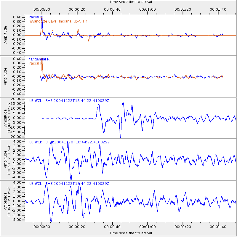
Signal To Noise
| Channel | StoN | STA | LTA |
| US:WCI: :BHN:20041128T18:44:22.410029Z | 4.83812 | 2.1005653E-6 | 4.3416972E-7 |
| US:WCI: :BHE:20041128T18:44:22.410029Z | 5.4158225 | 2.207308E-6 | 4.0756655E-7 |
| US:WCI: :BHZ:20041128T18:44:22.410029Z | 17.49323 | 7.9084475E-6 | 4.5208617E-7 |
| Arrivals |
| Ps | 4.2 SECOND |
| PpPs | 13 SECOND |
| PsPs/PpSs | 17 SECOND |


