You are here: Home > Network List > US - United States National Seismic Network Stations List
> Station WCI Wyandotte Cave, Indiana, USA > Earthquake Result Viewer
WCI Wyandotte Cave, Indiana, USA - Earthquake Result Viewer
| Earthquake location: |
Queen Charlotte Islands Region |
| Earthquake latitude/longitude: |
51.6/-131.1 |
| Earthquake time(UTC): |
2005/06/09 (160) 14:00:49 GMT |
| Earthquake Depth: |
10 km |
| Earthquake Magnitude: |
5.2 MB, 5.5 MS, 5.8 MW, 5.8 MW |
| Earthquake Catalog/Contributor: |
WHDF/NEIC |
|
| Network: |
US United States National Seismic Network |
| Station: |
WCI Wyandotte Cave, Indiana, USA |
| Lat/Lon: |
38.23 N/86.29 W |
| Elevation: |
500 m |
|
| Distance: |
33.9 deg |
| Az: |
95.305 deg |
| Baz: |
307.875 deg |
| Ray Param: |
0.077998385 |
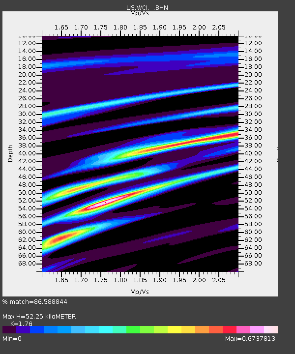
| Estimated Moho Depth: |
52.25 km |
| Estimated Crust Vp/Vs: |
1.76 |
| Assumed Crust Vp: |
6.444 km/s |
| Estimated Crust Vs: |
3.661 km/s |
| Estimated Crust Poisson's Ratio: |
0.26 |
|
| Radial Match: |
86.588844 % |
| Radial Bump: |
234 |
| Transverse Match: |
66.29419 % |
| Transverse Bump: |
400 |
| SOD ConfigId: |
110165 |
| Insert Time: |
2010-03-05 06:34:29.949 +0000 |
| GWidth: |
2.5 |
| Max Bumps: |
400 |
| Tol: |
0.001 |
|

Signal To Noise
| Channel | StoN | STA | LTA |
| US:WCI: :BHN:20050609T14:07:02.04801Z | 1.1704566 | 8.875512E-8 | 7.582948E-8 |
| US:WCI: :BHE:20050609T14:07:02.04801Z | 0.85651207 | 9.258465E-8 | 1.0809497E-7 |
| US:WCI: :BHZ:20050609T14:07:02.04801Z | 2.8635898 | 2.9520604E-7 | 1.030895E-7 |
| Arrivals |
| Ps | 6.7 SECOND |
| PpPs | 21 SECOND |
| PsPs/PpSs | 27 SECOND |


