You are here: Home > Network List > UU - University of Utah Regional Network Stations List
> Station LIUT Lila Canyon, UT, USA > Earthquake Result Viewer
LIUT Lila Canyon, UT, USA - Earthquake Result Viewer
| Earthquake location: |
Near Coast Of Central Chile |
| Earthquake latitude/longitude: |
-31.6/-71.7 |
| Earthquake time(UTC): |
2015/09/21 (264) 05:39:33 GMT |
| Earthquake Depth: |
23 km |
| Earthquake Magnitude: |
6.3 MWP |
| Earthquake Catalog/Contributor: |
NEIC PDE/NEIC COMCAT |
|
| Network: |
UU University of Utah Regional Network |
| Station: |
LIUT Lila Canyon, UT, USA |
| Lat/Lon: |
39.42 N/110.33 W |
| Elevation: |
2178 m |
|
| Distance: |
79.2 deg |
| Az: |
330.526 deg |
| Baz: |
147.171 deg |
| Ray Param: |
0.049077716 |
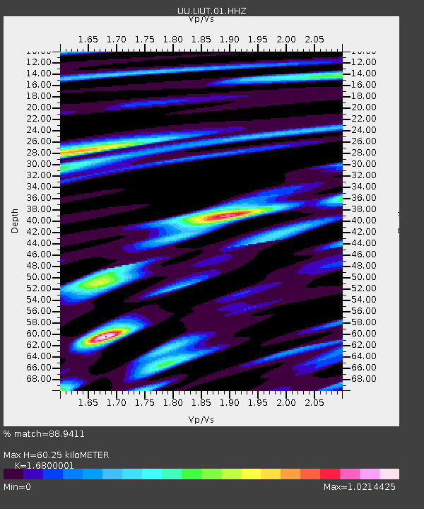
| Estimated Moho Depth: |
60.25 km |
| Estimated Crust Vp/Vs: |
1.68 |
| Assumed Crust Vp: |
6.207 km/s |
| Estimated Crust Vs: |
3.694 km/s |
| Estimated Crust Poisson's Ratio: |
0.23 |
|
| Radial Match: |
88.9411 % |
| Radial Bump: |
400 |
| Transverse Match: |
69.485214 % |
| Transverse Bump: |
400 |
| SOD ConfigId: |
1156111 |
| Insert Time: |
2015-10-05 06:35:51.439 +0000 |
| GWidth: |
2.5 |
| Max Bumps: |
400 |
| Tol: |
0.001 |
|

Signal To Noise
| Channel | StoN | STA | LTA |
| UU:LIUT:01:HHZ:20150921T05:51:05.500012Z | 11.369198 | 2.2246454E-8 | 1.9567303E-9 |
| UU:LIUT:01:HHN:20150921T05:51:05.500012Z | 3.3446312 | 7.2994872E-9 | 2.1824489E-9 |
| UU:LIUT:01:HHE:20150921T05:51:05.500012Z | 2.6151774 | 5.1517643E-9 | 1.9699484E-9 |
| Arrivals |
| Ps | 6.8 SECOND |
| PpPs | 25 SECOND |
| PsPs/PpSs | 32 SECOND |


