You are here: Home > Network List > TA - USArray Transportable Network (new EarthScope stations) Stations List
> Station J29M Klondike Camp, Yukon, CA > Earthquake Result Viewer
J29M Klondike Camp, Yukon, CA - Earthquake Result Viewer
| Earthquake location: |
New Ireland Region, P.N.G. |
| Earthquake latitude/longitude: |
-3.7/152.8 |
| Earthquake time(UTC): |
2016/08/31 (244) 03:11:36 GMT |
| Earthquake Depth: |
499 km |
| Earthquake Magnitude: |
6.7 MO |
| Earthquake Catalog/Contributor: |
NEIC PDE/NEIC ALERT |
|
| Network: |
TA USArray Transportable Network (new EarthScope stations) |
| Station: |
J29M Klondike Camp, Yukon, CA |
| Lat/Lon: |
64.45 N/138.22 W |
| Elevation: |
982 m |
|
| Distance: |
84.4 deg |
| Az: |
24.0 deg |
| Baz: |
249.407 deg |
| Ray Param: |
0.044102646 |
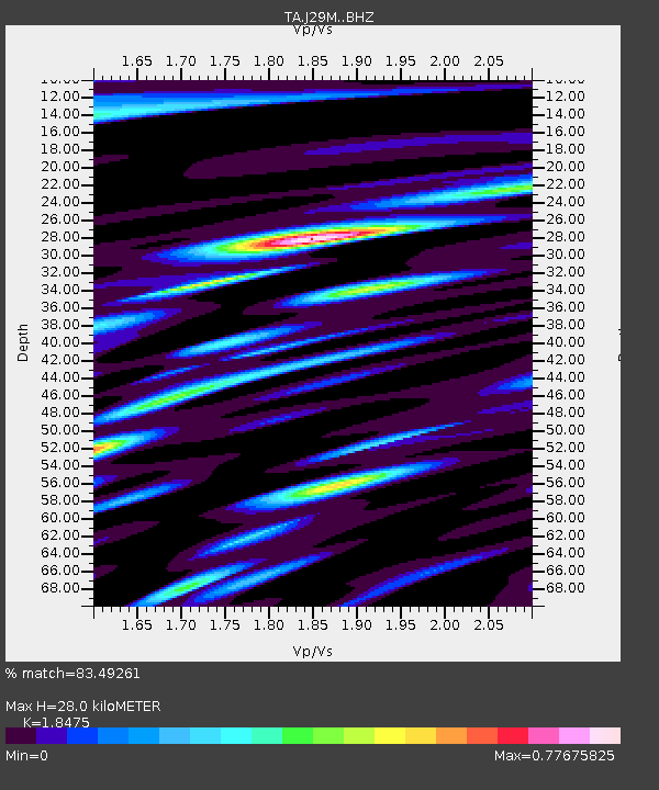
| Estimated Moho Depth: |
28.0 km |
| Estimated Crust Vp/Vs: |
1.85 |
| Assumed Crust Vp: |
6.566 km/s |
| Estimated Crust Vs: |
3.554 km/s |
| Estimated Crust Poisson's Ratio: |
0.29 |
|
| Radial Match: |
83.49261 % |
| Radial Bump: |
400 |
| Transverse Match: |
61.883198 % |
| Transverse Bump: |
400 |
| SOD ConfigId: |
11737051 |
| Insert Time: |
2019-04-25 09:44:50.200 +0000 |
| GWidth: |
2.5 |
| Max Bumps: |
400 |
| Tol: |
0.001 |
|

Signal To Noise
| Channel | StoN | STA | LTA |
| TA:J29M: :BHZ:20160831T03:22:44.099976Z | 6.336319 | 1.2281192E-6 | 1.9382219E-7 |
| TA:J29M: :BHN:20160831T03:22:44.099976Z | 4.4385443 | 5.415881E-7 | 1.2201932E-7 |
| TA:J29M: :BHE:20160831T03:22:44.099976Z | 6.4631114 | 6.7323737E-7 | 1.0416614E-7 |
| Arrivals |
| Ps | 3.7 SECOND |
| PpPs | 12 SECOND |
| PsPs/PpSs | 16 SECOND |


