You are here: Home > Network List > TA - USArray Transportable Network (new EarthScope stations) Stations List
> Station L19K White Mountain, AK, USA > Earthquake Result Viewer
L19K White Mountain, AK, USA - Earthquake Result Viewer
| Earthquake location: |
New Ireland Region, P.N.G. |
| Earthquake latitude/longitude: |
-3.7/152.8 |
| Earthquake time(UTC): |
2016/08/31 (244) 03:11:36 GMT |
| Earthquake Depth: |
499 km |
| Earthquake Magnitude: |
6.7 MO |
| Earthquake Catalog/Contributor: |
NEIC PDE/NEIC ALERT |
|
| Network: |
TA USArray Transportable Network (new EarthScope stations) |
| Station: |
L19K White Mountain, AK, USA |
| Lat/Lon: |
62.18 N/154.85 W |
| Elevation: |
650 m |
|
| Distance: |
76.7 deg |
| Az: |
22.436 deg |
| Baz: |
234.28 deg |
| Ray Param: |
0.04927434 |
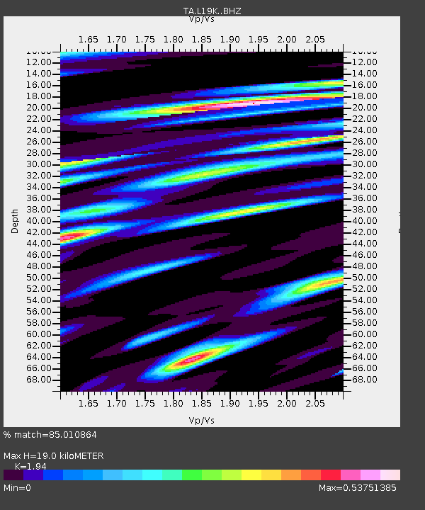
| Estimated Moho Depth: |
19.0 km |
| Estimated Crust Vp/Vs: |
1.94 |
| Assumed Crust Vp: |
6.438 km/s |
| Estimated Crust Vs: |
3.319 km/s |
| Estimated Crust Poisson's Ratio: |
0.32 |
|
| Radial Match: |
85.010864 % |
| Radial Bump: |
369 |
| Transverse Match: |
64.12707 % |
| Transverse Bump: |
400 |
| SOD ConfigId: |
11737051 |
| Insert Time: |
2019-04-25 09:44:57.893 +0000 |
| GWidth: |
2.5 |
| Max Bumps: |
400 |
| Tol: |
0.001 |
|
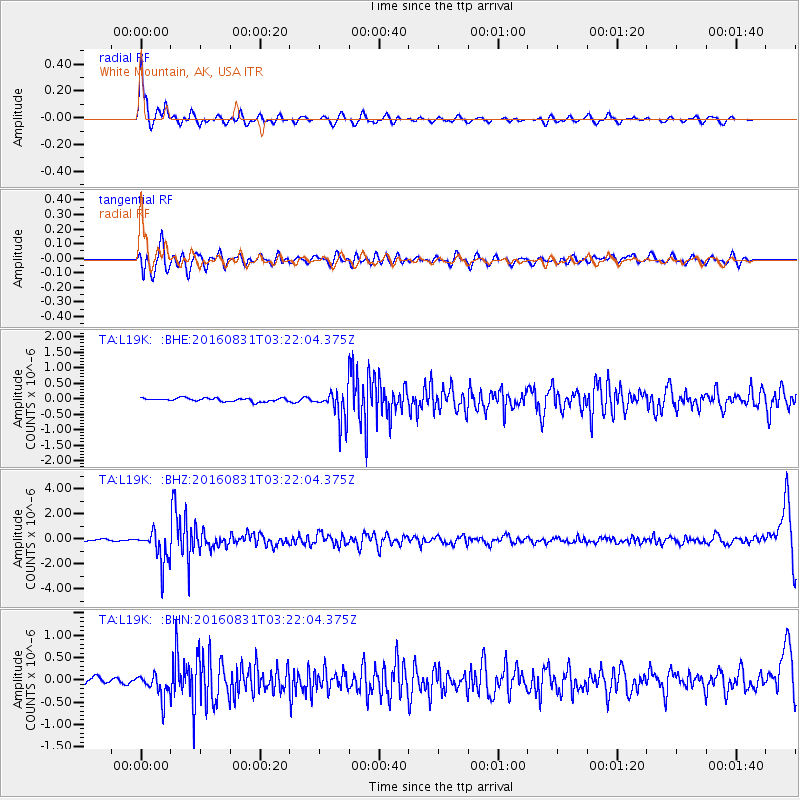
Signal To Noise
| Channel | StoN | STA | LTA |
| TA:L19K: :BHZ:20160831T03:22:04.375Z | 21.802462 | 1.3204314E-6 | 6.05634E-8 |
| TA:L19K: :BHN:20160831T03:22:04.375Z | 4.072134 | 2.6132162E-7 | 6.4173136E-8 |
| TA:L19K: :BHE:20160831T03:22:04.375Z | 8.927681 | 4.8716794E-7 | 5.456825E-8 |
| Arrivals |
| Ps | 2.8 SECOND |
| PpPs | 8.4 SECOND |
| PsPs/PpSs | 11 SECOND |


