You are here: Home > Network List > TA - USArray Transportable Network (new EarthScope stations) Stations List
> Station L29M Grand Valley Creek, YT, CAN > Earthquake Result Viewer
L29M Grand Valley Creek, YT, CAN - Earthquake Result Viewer
| Earthquake location: |
New Ireland Region, P.N.G. |
| Earthquake latitude/longitude: |
-3.7/152.8 |
| Earthquake time(UTC): |
2016/08/31 (244) 03:11:36 GMT |
| Earthquake Depth: |
499 km |
| Earthquake Magnitude: |
6.7 MO |
| Earthquake Catalog/Contributor: |
NEIC PDE/NEIC ALERT |
|
| Network: |
TA USArray Transportable Network (new EarthScope stations) |
| Station: |
L29M Grand Valley Creek, YT, CAN |
| Lat/Lon: |
63.11 N/138.13 W |
| Elevation: |
918 m |
|
| Distance: |
84.0 deg |
| Az: |
25.284 deg |
| Baz: |
249.615 deg |
| Ray Param: |
0.044400916 |
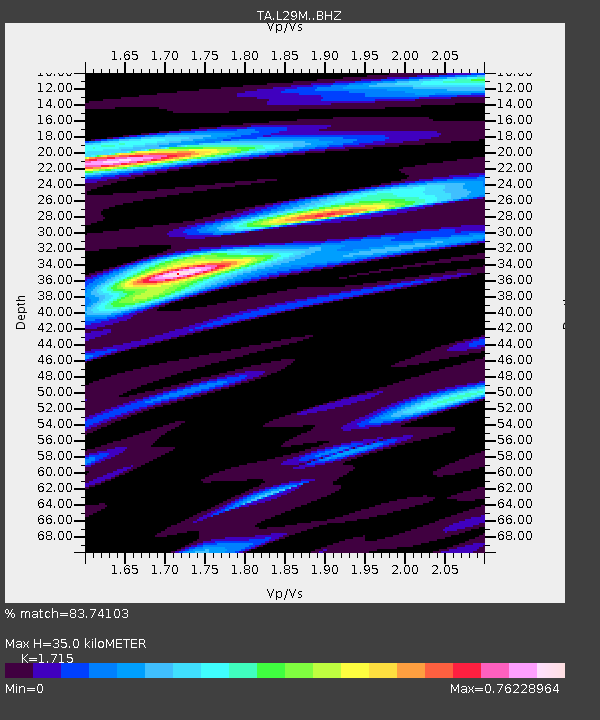
| Estimated Moho Depth: |
35.0 km |
| Estimated Crust Vp/Vs: |
1.72 |
| Assumed Crust Vp: |
6.566 km/s |
| Estimated Crust Vs: |
3.829 km/s |
| Estimated Crust Poisson's Ratio: |
0.24 |
|
| Radial Match: |
83.74103 % |
| Radial Bump: |
400 |
| Transverse Match: |
60.920692 % |
| Transverse Bump: |
400 |
| SOD ConfigId: |
11737051 |
| Insert Time: |
2019-04-25 09:45:00.500 +0000 |
| GWidth: |
2.5 |
| Max Bumps: |
400 |
| Tol: |
0.001 |
|
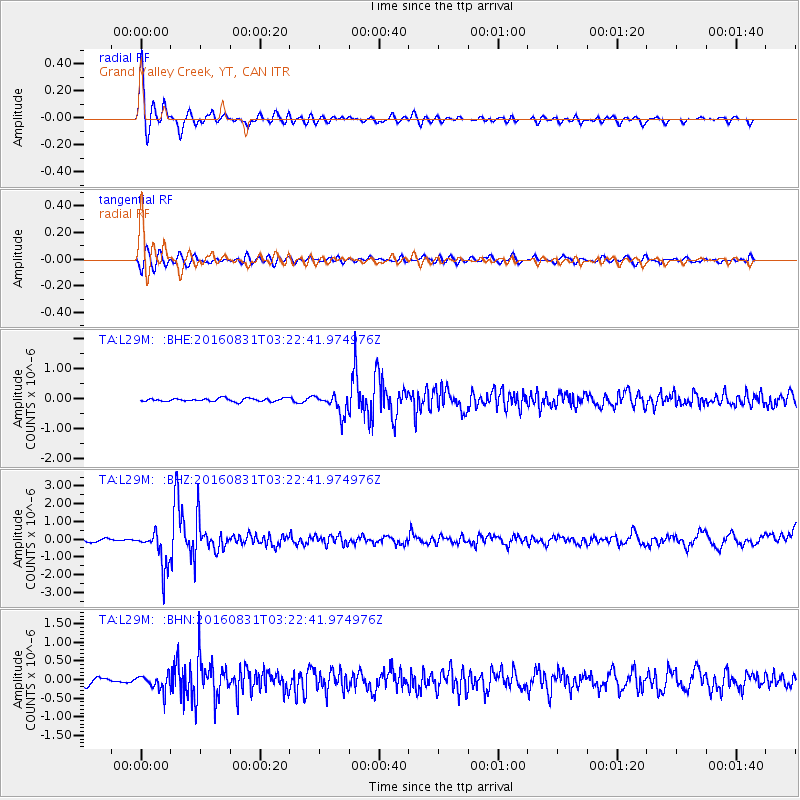
Signal To Noise
| Channel | StoN | STA | LTA |
| TA:L29M: :BHZ:20160831T03:22:41.974976Z | 13.129878 | 1.0548619E-6 | 8.034057E-8 |
| TA:L29M: :BHN:20160831T03:22:41.974976Z | 2.6853147 | 2.1563471E-7 | 8.030146E-8 |
| TA:L29M: :BHE:20160831T03:22:41.974976Z | 6.479396 | 3.4085005E-7 | 5.260522E-8 |
| Arrivals |
| Ps | 3.9 SECOND |
| PpPs | 14 SECOND |
| PsPs/PpSs | 18 SECOND |


