You are here: Home > Network List > TA - USArray Transportable Network (new EarthScope stations) Stations List
> Station O19K Port Alsworth, AK, USA > Earthquake Result Viewer
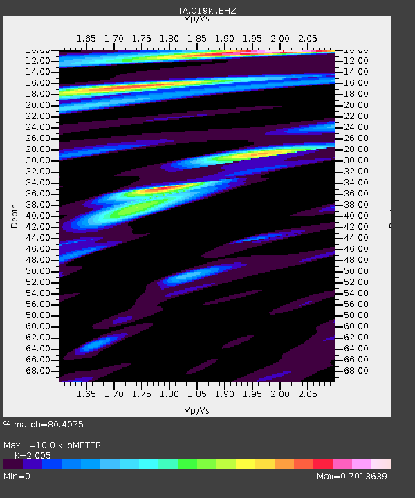
O19K Port Alsworth, AK, USA - Earthquake Result Viewer
| Earthquake location: |
New Ireland Region, P.N.G. |
| Earthquake latitude/longitude: |
-3.7/152.8 |
| Earthquake time(UTC): |
2016/08/31 (244) 03:11:36 GMT |
| Earthquake Depth: |
499 km |
| Earthquake Magnitude: |
6.7 MO |
| Earthquake Catalog/Contributor: |
NEIC PDE/NEIC ALERT |
|
| Network: |
TA USArray Transportable Network (new EarthScope stations) |
| Station: |
O19K Port Alsworth, AK, USA |
| Lat/Lon: |
60.20 N/154.32 W |
| Elevation: |
96 m |
|
| Distance: |
75.8 deg |
| Az: |
24.265 deg |
| Baz: |
235.182 deg |
| Ray Param: |
0.049888544 |
| Estimated Moho Depth: |
10.0 km |
| Estimated Crust Vp/Vs: |
2.01 |
| Assumed Crust Vp: |
6.566 km/s |
| Estimated Crust Vs: |
3.275 km/s |
| Estimated Crust Poisson's Ratio: |
0.33 |
|
| Radial Match: |
80.4075 % |
| Radial Bump: |
400 |
| Transverse Match: |
63.020496 % |
| Transverse Bump: |
400 |
| SOD ConfigId: |
11737051 |
| Insert Time: |
2019-04-25 09:45:17.210 +0000 |
| GWidth: |
2.5 |
| Max Bumps: |
400 |
| Tol: |
0.001 |
|

Signal To Noise
| Channel | StoN | STA | LTA |
| TA:O19K: :BHZ:20160831T03:21:59.200012Z | 20.69049 | 1.461646E-6 | 7.064337E-8 |
| TA:O19K: :BHN:20160831T03:21:59.200012Z | 7.1862545 | 5.021851E-7 | 6.9881345E-8 |
| TA:O19K: :BHE:20160831T03:21:59.200012Z | 6.5188246 | 4.152652E-7 | 6.3702466E-8 |
| Arrivals |
| Ps | 1.6 SECOND |
| PpPs | 4.5 SECOND |
| PsPs/PpSs | 6.0 SECOND |


