You are here: Home > Network List > UW - Pacific Northwest Regional Seismic Network Stations List
> Station PASS Maple Falls, WA, USA > Earthquake Result Viewer
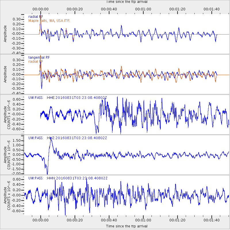
PASS Maple Falls, WA, USA - Earthquake Result Viewer
*The percent match for this event was below the threshold and hence no stack was calculated.
| Earthquake location: |
New Ireland Region, P.N.G. |
| Earthquake latitude/longitude: |
-3.7/152.8 |
| Earthquake time(UTC): |
2016/08/31 (244) 03:11:36 GMT |
| Earthquake Depth: |
499 km |
| Earthquake Magnitude: |
6.7 MO |
| Earthquake Catalog/Contributor: |
NEIC PDE/NEIC ALERT |
|
| Network: |
UW Pacific Northwest Regional Seismic Network |
| Station: |
PASS Maple Falls, WA, USA |
| Lat/Lon: |
49.00 N/122.09 W |
| Elevation: |
174 m |
|
| Distance: |
89.6 deg |
| Az: |
41.013 deg |
| Baz: |
263.92 deg |
| Ray Param: |
$rayparam |
*The percent match for this event was below the threshold and hence was not used in the summary stack. |
|
| Radial Match: |
60.198772 % |
| Radial Bump: |
400 |
| Transverse Match: |
59.42369 % |
| Transverse Bump: |
400 |
| SOD ConfigId: |
11737051 |
| Insert Time: |
2019-04-25 09:46:16.948 +0000 |
| GWidth: |
2.5 |
| Max Bumps: |
400 |
| Tol: |
0.001 |
|
Signal To Noise
| Channel | StoN | STA | LTA |
| UW:PASS: :HHZ:20160831T03:23:08.40802Z | 5.283239 | 8.716034E-7 | 1.6497519E-7 |
| UW:PASS: :HHN:20160831T03:23:08.40802Z | 1.319965 | 1.8212468E-7 | 1.379769E-7 |
| UW:PASS: :HHE:20160831T03:23:08.40802Z | 2.6189623 | 3.787751E-7 | 1.4462793E-7 |
| Arrivals |
| Ps | |
| PpPs | |
| PsPs/PpSs | |


