You are here: Home > Network List > US - United States National Seismic Network Stations List
> Station WCI Wyandotte Cave, Indiana, USA > Earthquake Result Viewer
WCI Wyandotte Cave, Indiana, USA - Earthquake Result Viewer
| Earthquake location: |
Kuril Islands |
| Earthquake latitude/longitude: |
46.5/153.2 |
| Earthquake time(UTC): |
2006/10/01 (274) 09:06:02 GMT |
| Earthquake Depth: |
19 km |
| Earthquake Magnitude: |
6.1 MB, 6.4 MS, 6.6 MW, 6.5 MW |
| Earthquake Catalog/Contributor: |
WHDF/NEIC |
|
| Network: |
US United States National Seismic Network |
| Station: |
WCI Wyandotte Cave, Indiana, USA |
| Lat/Lon: |
38.23 N/86.29 W |
| Elevation: |
500 m |
|
| Distance: |
80.2 deg |
| Az: |
43.533 deg |
| Baz: |
322.81 deg |
| Ray Param: |
0.048389275 |
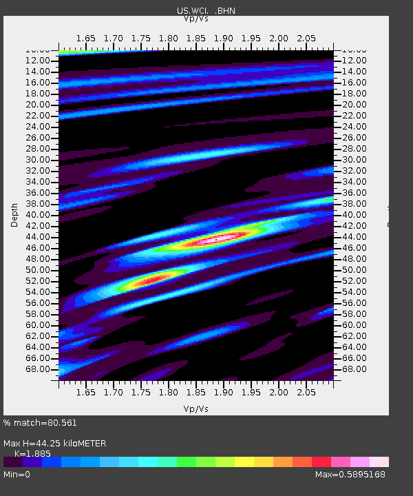
| Estimated Moho Depth: |
44.25 km |
| Estimated Crust Vp/Vs: |
1.88 |
| Assumed Crust Vp: |
6.444 km/s |
| Estimated Crust Vs: |
3.419 km/s |
| Estimated Crust Poisson's Ratio: |
0.30 |
|
| Radial Match: |
80.561 % |
| Radial Bump: |
286 |
| Transverse Match: |
54.977985 % |
| Transverse Bump: |
359 |
| SOD ConfigId: |
2665 |
| Insert Time: |
2010-03-05 06:35:14.083 +0000 |
| GWidth: |
2.5 |
| Max Bumps: |
400 |
| Tol: |
0.001 |
|

Signal To Noise
| Channel | StoN | STA | LTA |
| US:WCI: :BHN:20061001T09:17:40.285027Z | 0.96886414 | 2.856907E-7 | 2.9487177E-7 |
| US:WCI: :BHE:20061001T09:17:40.285027Z | 1.9838238 | 3.041462E-7 | 1.5331311E-7 |
| US:WCI: :BHZ:20061001T09:17:40.285027Z | 2.5596635 | 7.6166685E-7 | 2.975652E-7 |
| Arrivals |
| Ps | 6.2 SECOND |
| PpPs | 19 SECOND |
| PsPs/PpSs | 26 SECOND |


