You are here: Home > Network List > US - United States National Seismic Network Stations List
> Station WCI Wyandotte Cave, Indiana, USA > Earthquake Result Viewer
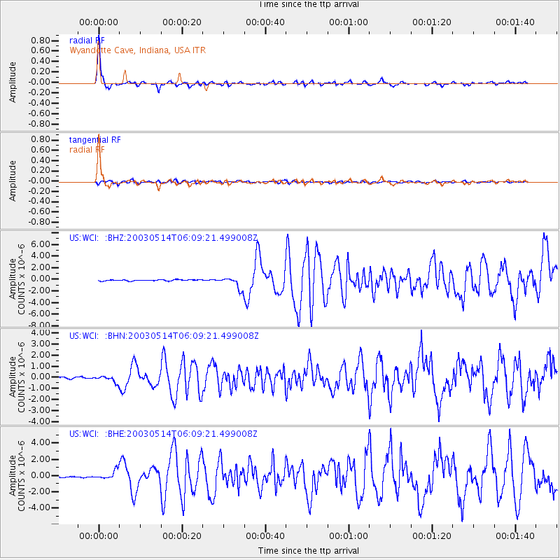
WCI Wyandotte Cave, Indiana, USA - Earthquake Result Viewer

| Earthquake location: |
North Atlantic Ocean |
| Earthquake latitude/longitude: |
18.3/-58.6 |
| Earthquake time(UTC): |
2003/05/14 (134) 06:03:35 GMT |
| Earthquake Depth: |
42 km |
| Earthquake Magnitude: |
6.5 MB, 6.5 MS, 6.6 MW, 6.6 MW |
| Earthquake Catalog/Contributor: |
WHDF/NEIC |
|
| Network: |
US United States National Seismic Network |
| Station: |
WCI Wyandotte Cave, Indiana, USA |
| Lat/Lon: |
38.23 N/86.29 W |
| Elevation: |
500 m |
|
| Distance: |
31.3 deg |
| Az: |
315.207 deg |
| Baz: |
121.78 deg |
| Ray Param: |
0.0790694 |
| Estimated Moho Depth: |
26.25 km |
| Estimated Crust Vp/Vs: |
1.86 |
| Assumed Crust Vp: |
6.444 km/s |
| Estimated Crust Vs: |
3.46 km/s |
| Estimated Crust Poisson's Ratio: |
0.30 |
|
| Radial Match: |
88.94391 % |
| Radial Bump: |
314 |
| Transverse Match: |
62.33613 % |
| Transverse Bump: |
400 |
| SOD ConfigId: |
110177 |
| Insert Time: |
2010-03-05 06:35:50.268 +0000 |
| GWidth: |
2.5 |
| Max Bumps: |
400 |
| Tol: |
0.001 |
|
Signal To Noise
| Channel | StoN | STA | LTA |
| US:WCI: :BHN:20030514T06:09:21.499008Z | 3.5811174 | 3.057629E-7 | 8.5381984E-8 |
| US:WCI: :BHE:20030514T06:09:21.499008Z | 9.241344 | 5.634383E-7 | 6.096929E-8 |
| US:WCI: :BHZ:20030514T06:09:21.499008Z | 11.08914 | 1.0814947E-6 | 9.752737E-8 |
| Arrivals |
| Ps | 3.8 SECOND |
| PpPs | 11 SECOND |
| PsPs/PpSs | 15 SECOND |


