You are here: Home > Network List > PY - PFO Array Stations List
> Station BPH04 Pinon Flat Observatory, CA, USA > Earthquake Result Viewer
BPH04 Pinon Flat Observatory, CA, USA - Earthquake Result Viewer
| Earthquake location: |
Off E. Coast Of N. Island, N.Z. |
| Earthquake latitude/longitude: |
-37.4/179.1 |
| Earthquake time(UTC): |
2016/09/01 (245) 16:37:57 GMT |
| Earthquake Depth: |
19 km |
| Earthquake Magnitude: |
7.1 MWW, 7.0 MWW, 7.2 MI |
| Earthquake Catalog/Contributor: |
NEIC PDE/NEIC COMCAT |
|
| Network: |
PY PFO Array |
| Station: |
BPH04 Pinon Flat Observatory, CA, USA |
| Lat/Lon: |
33.61 N/116.46 W |
| Elevation: |
1287 m |
|
| Distance: |
92.7 deg |
| Az: |
48.938 deg |
| Baz: |
226.015 deg |
| Ray Param: |
0.041403815 |
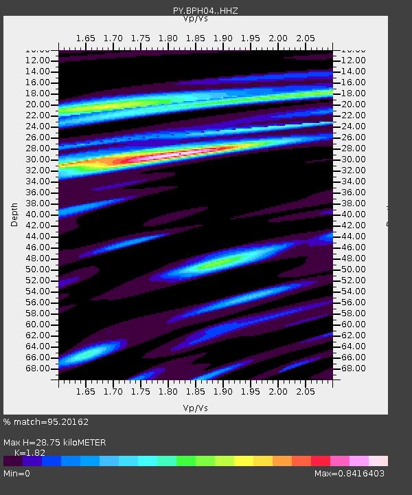
| Estimated Moho Depth: |
28.75 km |
| Estimated Crust Vp/Vs: |
1.82 |
| Assumed Crust Vp: |
6.264 km/s |
| Estimated Crust Vs: |
3.442 km/s |
| Estimated Crust Poisson's Ratio: |
0.28 |
|
| Radial Match: |
95.20162 % |
| Radial Bump: |
395 |
| Transverse Match: |
88.2317 % |
| Transverse Bump: |
400 |
| SOD ConfigId: |
11737051 |
| Insert Time: |
2019-04-25 09:55:16.352 +0000 |
| GWidth: |
2.5 |
| Max Bumps: |
400 |
| Tol: |
0.001 |
|

Signal To Noise
| Channel | StoN | STA | LTA |
| PY:BPH04: :HHZ:20160901T16:50:35.974998Z | 0.7216885 | 5.479122E-8 | 7.5920866E-8 |
| PY:BPH04: :HHN:20160901T16:50:35.974998Z | 1.7203516 | 1.1656864E-7 | 6.775862E-8 |
| PY:BPH04: :HHE:20160901T16:50:35.974998Z | 0.82959336 | 5.8560314E-8 | 7.058918E-8 |
| Arrivals |
| Ps | 3.8 SECOND |
| PpPs | 13 SECOND |
| PsPs/PpSs | 17 SECOND |


