You are here: Home > Network List > PS - Pacific21 Stations List
> Station PSI Parapat, Indonesia > Earthquake Result Viewer
PSI Parapat, Indonesia - Earthquake Result Viewer

| Earthquake location: |
Off E. Coast Of N. Island, N.Z. |
| Earthquake latitude/longitude: |
-37.4/179.1 |
| Earthquake time(UTC): |
2016/09/01 (245) 16:37:57 GMT |
| Earthquake Depth: |
19 km |
| Earthquake Magnitude: |
7.1 MWW, 7.0 MWW, 7.2 MI |
| Earthquake Catalog/Contributor: |
NEIC PDE/NEIC COMCAT |
|
| Network: |
PS Pacific21 |
| Station: |
PSI Parapat, Indonesia |
| Lat/Lon: |
2.69 N/98.92 E |
| Elevation: |
987 m |
|
| Distance: |
83.8 deg |
| Az: |
278.138 deg |
| Baz: |
127.888 deg |
| Ray Param: |
0.045918792 |
| Estimated Moho Depth: |
62.25 km |
| Estimated Crust Vp/Vs: |
1.69 |
| Assumed Crust Vp: |
6.468 km/s |
| Estimated Crust Vs: |
3.833 km/s |
| Estimated Crust Poisson's Ratio: |
0.23 |
|
| Radial Match: |
93.505974 % |
| Radial Bump: |
400 |
| Transverse Match: |
87.83913 % |
| Transverse Bump: |
400 |
| SOD ConfigId: |
11737051 |
| Insert Time: |
2019-04-25 09:55:22.398 +0000 |
| GWidth: |
2.5 |
| Max Bumps: |
400 |
| Tol: |
0.001 |
|
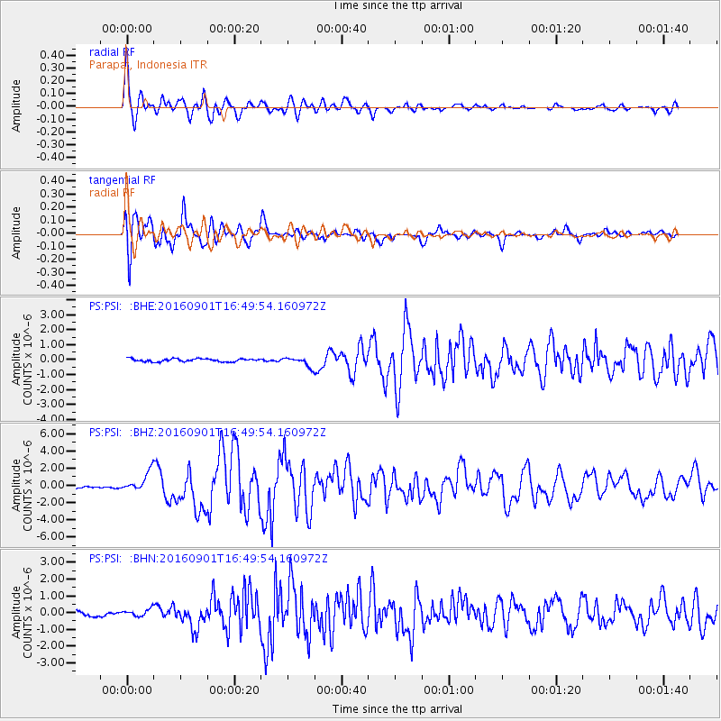
Signal To Noise
| Channel | StoN | STA | LTA |
| PS:PSI: :BHZ:20160901T16:49:54.160972Z | 11.113549 | 1.1445563E-6 | 1.0298747E-7 |
| PS:PSI: :BHN:20160901T16:49:54.160972Z | 2.068099 | 2.170383E-7 | 1.049458E-7 |
| PS:PSI: :BHE:20160901T16:49:54.160972Z | 3.5057595 | 3.4919162E-7 | 9.9605124E-8 |
| Arrivals |
| Ps | 6.8 SECOND |
| PpPs | 25 SECOND |
| PsPs/PpSs | 32 SECOND |


