You are here: Home > Network List > US - United States National Seismic Network Stations List
> Station WCI Wyandotte Cave, Indiana, USA > Earthquake Result Viewer
WCI Wyandotte Cave, Indiana, USA - Earthquake Result Viewer
| Earthquake location: |
Hokkaido, Japan Region |
| Earthquake latitude/longitude: |
42.6/144.6 |
| Earthquake time(UTC): |
2003/10/08 (281) 09:06:55 GMT |
| Earthquake Depth: |
32 km |
| Earthquake Magnitude: |
6.0 MB, 6.6 MS, 6.7 MW, 6.6 MW |
| Earthquake Catalog/Contributor: |
WHDF/NEIC |
|
| Network: |
US United States National Seismic Network |
| Station: |
WCI Wyandotte Cave, Indiana, USA |
| Lat/Lon: |
38.23 N/86.29 W |
| Elevation: |
500 m |
|
| Distance: |
87.2 deg |
| Az: |
37.706 deg |
| Baz: |
325.043 deg |
| Ray Param: |
0.04347023 |
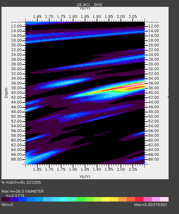
| Estimated Moho Depth: |
36.0 km |
| Estimated Crust Vp/Vs: |
2.08 |
| Assumed Crust Vp: |
6.444 km/s |
| Estimated Crust Vs: |
3.102 km/s |
| Estimated Crust Poisson's Ratio: |
0.35 |
|
| Radial Match: |
91.023285 % |
| Radial Bump: |
397 |
| Transverse Match: |
75.50705 % |
| Transverse Bump: |
400 |
| SOD ConfigId: |
110177 |
| Insert Time: |
2010-03-05 06:36:10.248 +0000 |
| GWidth: |
2.5 |
| Max Bumps: |
400 |
| Tol: |
0.001 |
|

Signal To Noise
| Channel | StoN | STA | LTA |
| US:WCI: :BHN:20031008T09:19:07.035007Z | 2.42674 | 4.928351E-7 | 2.0308526E-7 |
| US:WCI: :BHE:20031008T09:19:07.035007Z | 2.5136282 | 5.771966E-7 | 2.2962688E-7 |
| US:WCI: :BHZ:20031008T09:19:07.035007Z | 5.0224075 | 1.4897837E-6 | 2.966274E-7 |
| Arrivals |
| Ps | 6.1 SECOND |
| PpPs | 17 SECOND |
| PsPs/PpSs | 23 SECOND |


